|
search place name
|
||
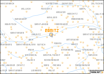
Ranitz (Kärnten, Austria)Ranitz is a town in the Kärnten region of Austria. An overview map of the region around Ranitz is displayed below.
regional and 3d topo map of Ranitz, Austria ::
Ranitz airports ::
The nearest airport is KLU - Klagenfurt (Worthersee Intl), located 25.3 km south of Ranitz.
Other airports nearby include LJU - Ljubliana Ljubljana (72.7 km south), GRZ - Graz (89.1 km east), MBX - Maribor (115.6 km east), TRS - Ronchi De Legionari Ronchi Dei Legionari (131.3 km south west), Nearby towns ::
Gurk (1.0km north east) //
Sankt Peter (1.9km north) //
Reichenhaus (1.3km west) //
Pisweg (1.9km south) //
Mitterdorf (3.6km north) //
Finsterdorf (3.7km south) //
Föbing (3.6km south east) //
Hausdorf (3.9km north) //
Lieding (3.1km north east) //
Gassarest (3.9km north west) //
Langwiesen (4.8km north) //
Gruska (4.5km south west) //
Gray (5.0km south) //
Sankt Jakob (4.5km north west) //
Mannsdorf (4.5km north east) //
Sutsch (4.5km south west) //
Äußere Wimitz (4.5km south east) //
Zweinitz (3.8km west) //
Schneßnitz (5.7km north) //
Predl (5.7km south) //
Straßburg (4.6km north east) //
Frauenstein (5.9km south) //
Winklern (6.1km north) //
Leiten (5.3km south east) //
Eggen (6.1km south east) //
Dreifaltigkeit (7.4km south) //
Kraßnitz (5.4km west) //
Aich (5.4km west) //
Unterdeka (5.4km east) //
[all distances 'as the bird flies' and approximate] 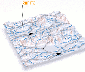 Places with similar names to Ranitz, Austria ::
Disclaimer :: Information on this page comes without warranty of any kind |
||
|
Where is Ranitz? Elevation and coordinates ::
Latitude (lat): 46°52'0"N Longitude (lon): 14°17'0"E
Elevation (approx.): 788m (map arrows pan, magnifying glasses zoom) |
||
|
Visiting Ranitz? Hotel/Accommodation ::
Book a hotel in Ranitz Travel Guide ::
Buy a travel guide for Austria rental cars ::
car rental offers GPS waypoint ::
download a GPX waypoint (PoI) of Ranitz for your GPS receiver
|
||