|
search place name
|
||
Sankt Adolari (Tirol, Austria)Sankt Adolari is a town in the Tirol region of Austria. An overview map of the region around Sankt Adolari is displayed below.
regional and 3d topo map of Sankt Adolari, Austria ::

Sankt Adolari airports ::
The nearest airport is SZG - Salzburg, located 42.6 km north east of Sankt Adolari.
Other airports nearby include INN - Innsbruck (97.7 km west), MUC - Munich Munchen (106.7 km north west), OBF - Oberpfaffenhofen (112.8 km north west), FEL - Fuerstenfeldbruck Furstenfeldbruck (121.5 km north west), Nearby towns ::
Sankt Ulrich am Pillersee (1.9km south) //
Winkl (1.9km north) //
Waidring (3.7km north) //
Schwendt (3.9km south) //
Weissleiten (4.5km south east) //
Flecken (5.7km south) //
Mühlau (5.7km south) //
Sankt Jakob in Haus (5.7km south) //
Hausergasse (5.7km north) //
Strub (5.3km north east) //
Reiterdörfl (5.3km north west) //
Filzen (6.1km south west) //
Pertrach (7.5km south) //
Fieberbrunn (7.5km south) //
Enterpfarr (6.7km south west) //
Innerwald (6.2km north west) //
Moosbach (7.8km south) //
Lehmgrube (7.8km south) //
Hütte (7.8km south) //
Schönau (7.8km south) //
Warming (8.3km south east) //
Bärfeld (8.9km south west) //
[all distances 'as the bird flies' and approximate] 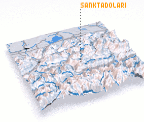 Places with similar names to Sankt Adolari, Austria ::
Disclaimer :: Information on this page comes without warranty of any kind |
||
|
Where is Sankt Adolari? Elevation and coordinates ::
Latitude (lat): 47°33'0"N Longitude (lon): 12°34'0"E
Elevation (approx.): 854m (map arrows pan, magnifying glasses zoom) |
||
|
Visiting Sankt Adolari? Hotel/Accommodation ::
Book a hotel in Sankt Adolari Travel Guide ::
Buy a travel guide for Austria rental cars ::
car rental offers GPS waypoint ::
download a GPX waypoint (PoI) of Sankt Adolari for your GPS receiver
|
||