|
search place name
|
||
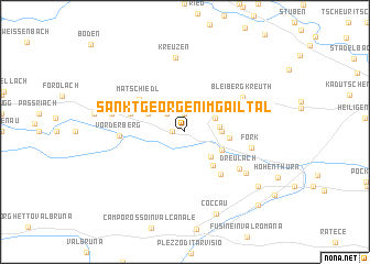
Sankt Georgen im Gailtal (Kärnten, Austria)Sankt Georgen im Gailtal is a town in the Kärnten region of Austria. An overview map of the region around Sankt Georgen im Gailtal is displayed below.
regional and 3d topo map of Sankt Georgen im Gailtal, Austria ::
nearby GPS traces from timatio ::
Sankt Georgen im Gailtal airports ::
The nearest airport is KLU - Klagenfurt (Worthersee Intl), located 58.0 km east of Sankt Georgen im Gailtal.
Other airports nearby include LJU - Ljubliana Ljubljana (79.2 km south east), TRS - Ronchi De Legionari Ronchi Dei Legionari (86.3 km south), AVB - Aviano Ab (Pagliano E Gori) (98.8 km south west), POW - Portoroz (125.3 km south), Nearby towns ::
Emmersdorf (0.9km west) //
Semering (1.9km north) //
Kreublach (2.2km north west) //
Kerschdorf (2.6km north west) //
Wertschach (2.6km north east) //
Labientschach (2.4km east) //
Feistritz an der Gail (3.1km south east) //
Hermsberg (2.5km east) //
Hadersdorf (3.1km north west) //
Nötsch (3.2km south east) //
Achomitz (4.0km south east) //
Saak (3.2km east) //
Göriach (4.9km south east) //
Matschiedl (4.6km north west) //
Tratten (4.5km north west) //
Bach (4.2km north west) //
Vorderberg (4.6km west) //
Dreulach (5.3km south east) //
Bleiberg-Kreuth (5.4km north east) //
Förk (4.9km east) //
Sankt Paul an der Gail (5.2km north west) //
Draschitz (5.9km south east) //
Nötsch bei Bleiberg (5.6km north east) //
Kreuzen (7.6km north) //
Sankt Stefan an der Gail (5.4km west) //
Edling (5.4km west) //
Coccau (8.6km south) //
Pessendellach (7.5km south east) //
Unterthörl (9.0km south east) //
[all distances 'as the bird flies' and approximate]  Places with similar names to Sankt Georgen im Gailtal, Austria :: Disclaimer :: Information on this page comes without warranty of any kind |
||
|
Where is Sankt Georgen im Gailtal? Elevation and coordinates ::
Latitude (lat): 46°36'0"N Longitude (lon): 13°35'0"E
Elevation (approx.): 617m (map arrows pan, magnifying glasses zoom) |
||
|
Visiting Sankt Georgen im Gailtal? Hotel/Accommodation ::
Book a hotel in Sankt Georgen im Gailtal Travel Guide ::
Buy a travel guide for Austria rental cars ::
car rental offers GPS waypoint ::
download a GPX waypoint (PoI) of Sankt Georgen im Gailtal for your GPS receiver
|
||