|
search place name
|
||
Sankt Veit (Tirol, Austria)Sankt Veit is a town in the Tirol region of Austria. An overview map of the region around Sankt Veit is displayed below.
regional and 3d topo map of Sankt Veit, Austria ::

Sankt Veit airports ::
The nearest airport is INN - Innsbruck, located 21.9 km east of Sankt Veit.
Other airports nearby include OBF - Oberpfaffenhofen (86.6 km north), BZO - Bolzano (97.2 km south), FEL - Fuerstenfeldbruck Furstenfeldbruck (100.0 km north), ACH - St Gallen Altenrhein (115.2 km west), Nearby towns ::
Telfs (1.9km south) //
Oberhofen im Inntal (2.2km south east) //
Pfaffenhofen (2.2km south east) //
Höll (2.2km south east) //
Sagl (2.5km east) //
Rietz (3.9km south) //
Thannrain (4.5km south west) //
Wildermieming (3.8km west) //
Buchen (4.2km north east) //
Mooshäuser (5.3km north east) //
Flaurling (5.3km south east) //
Haslach (5.3km south west) //
Platten (5.4km east) //
Pettnau (5.4km east) //
Obern (6.7km north east) //
Platzl (6.2km north east) //
Tillfussalm (7.8km north) //
Hauland (6.2km south west) //
Windfang (6.2km south west) //
[all distances 'as the bird flies' and approximate] 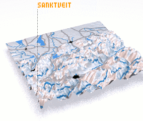 Places with similar names to Sankt Veit, Austria ::
// Sanga do Veado (BR)
// Sankt Veit (AT)
// Sankt Veit (DE)
// Sankt Veit (DE)
// Sankt Veit (DE)
// Sankt Vit (DE)
Disclaimer :: Information on this page comes without warranty of any kind |
||
|
Where is Sankt Veit? Elevation and coordinates ::
Latitude (lat): 47°19'0"N Longitude (lon): 11°4'0"E
Elevation (approx.): 777m (map arrows pan, magnifying glasses zoom) |
||
|
Visiting Sankt Veit? Hotel/Accommodation ::
Book a hotel in Sankt Veit Travel Guide ::
Buy a travel guide for Austria rental cars ::
car rental offers GPS waypoint ::
download a GPX waypoint (PoI) of Sankt Veit for your GPS receiver
|
||