|
search place name
|
||
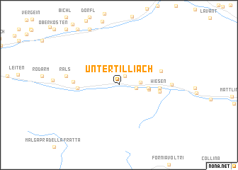
Untertilliach (Tirol, Austria)Untertilliach is a town in the Tirol region of Austria. An overview map of the region around Untertilliach is displayed below.
regional and 3d topo map of Untertilliach, Austria ::
Untertilliach airports ::
The nearest airport is AVB - Aviano Ab (Pagliano E Gori), located 75.2 km south of Untertilliach.
Other airports nearby include BZO - Bolzano (109.4 km west), TRS - Ronchi De Legionari Ronchi Dei Legionari (113.8 km south east), INN - Innsbruck (120.8 km north west), SZG - Salzburg (123.1 km north), Nearby towns ::
Guggenberg (1.5km north east) //
Sallach (1.5km north east) //
Raut (1.9km east) //
Tiefenbach (1.9km east) //
Maria Luggau (2.4km east) //
Sterzen (3.2km east) //
Moos (3.3km east) //
Wiesen (4.5km east) //
Frohn (4.5km east) //
Winkl (4.5km west) //
Huben (4.5km west) //
Tuffbad (5.0km north east) //
Bergen (5.0km west) //
Sankt Lorenzen im Lesachtal (5.7km east) //
Rals (5.9km west) //
Aue (9.4km north) //
Thal (9.9km north west) //
Oberassling (10.5km north west) //
[all distances 'as the bird flies' and approximate]  Places with similar names to Untertilliach, Austria ::
// Unter-Dellach (AT)
Disclaimer :: Information on this page comes without warranty of any kind |
||
|
Where is Untertilliach? Elevation and coordinates ::
Latitude (lat): 46°42'15"N Longitude (lon): 12°42'31"E
Elevation (approx.): 1169m (map arrows pan, magnifying glasses zoom) |
||
|
Visiting Untertilliach? Hotel/Accommodation ::
Book a hotel in Untertilliach Travel Guide ::
Buy a travel guide for Austria rental cars ::
car rental offers GPS waypoint ::
download a GPX waypoint (PoI) of Untertilliach for your GPS receiver
|
||