|
search place name
|
||
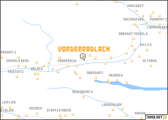
Vorderradlach (Kärnten, Austria)Vorderradlach is a town in the Kärnten region of Austria. An overview map of the region around Vorderradlach is displayed below.
regional and 3d topo map of Vorderradlach, Austria ::
Vorderradlach airports ::
The nearest airport is KLU - Klagenfurt (Worthersee Intl), located 84.3 km east of Vorderradlach.
Other airports nearby include AVB - Aviano Ab (Pagliano E Gori) (95.4 km south west), TRS - Ronchi De Legionari Ronchi Dei Legionari (105.2 km south), LJU - Ljubliana Ljubljana (110.4 km south east), SZG - Salzburg (116.2 km north), Nearby towns ::
Gerlamoos (1.4km north east) //
Hinterradlach (1.7km south west) //
Steinfeld (1.8km east) //
Rottenstein (2.7km north west) //
Waisach (3.0km south west) //
Tröbelsberg (3.3km south) //
Pobersach (2.8km south west) //
Kreuzberg (4.0km south) //
Oberdorf (4.3km south east) //
Gajach (3.4km east) //
Gnoppnitz (3.8km west) //
Kerschbaum (3.8km west) //
Lengholz (4.2km east) //
Bruggen (4.8km south west) //
Techendorf (5.9km south east) //
Hauzendorf (5.3km west) //
Gatschach (6.3km south east) //
Greifenburg (5.5km west) //
Weissbriach (8.2km south) //
Neusach (6.7km south east) //
[all distances 'as the bird flies' and approximate]  Places with similar names to Vorderradlach, Austria :: Disclaimer :: Information on this page comes without warranty of any kind |
||
|
Where is Vorderradlach? Elevation and coordinates ::
Latitude (lat): 46°45'41"N Longitude (lon): 13°14'56"E
Elevation (approx.): 655m (map arrows pan, magnifying glasses zoom) |
||
|
Visiting Vorderradlach? Hotel/Accommodation ::
Book a hotel in Vorderradlach Travel Guide ::
Buy a travel guide for Austria rental cars ::
car rental offers GPS waypoint ::
download a GPX waypoint (PoI) of Vorderradlach for your GPS receiver
|
||