|
search place name
|
||
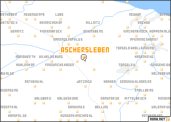
Aschersleben (Mecklenburg-Vorpommern, Germany)Aschersleben is a town in the Mecklenburg-Vorpommern region of Germany. An overview map of the region around Aschersleben is displayed below.
regional and 3d topo map of Aschersleben, Germany ::
Aschersleben airports ::
The nearest airport is SZZ - Szczechin Goleniow, located 64.5 km east of Aschersleben.
Other airports nearby include RLG - Laage (113.1 km west), TXL - Berlin Tegel (128.8 km south), THF - Berlin Tempelhof (135.7 km south), SXF - Berlin Schonefeld (144.0 km south), Nearby towns ::
Heinrichsruh (1.1km west) //
Müggenburg (2.2km south east) //
Blumenthal (3.9km north) //
Zarow (4.3km north west) //
Sprengersfelde (4.3km north west) //
Jatznick (5.6km south) //
Ferdinandshof (3.8km north west) //
Friedrichshagen (3.8km south west) //
Meiersberg (5.7km north) //
Louisenhof (6.0km north) //
Johannisberg (4.4km west) //
Wilhelmsburg (4.4km west) //
Millnitz (7.5km north) //
Hammer (6.5km south east) //
Annenhof (7.7km north) //
Finkenbrück (7.1km north west) //
Jädkemühl (7.1km north east) //
Heinrichshof (8.6km north west) //
[all distances 'as the bird flies' and approximate]  Places with similar names to Aschersleben, Germany ::
// Aschersleben (DE)
Disclaimer :: Information on this page comes without warranty of any kind |
||
|
Where is Aschersleben? Elevation and coordinates ::
Latitude (lat): 53°39'0"N Longitude (lon): 13°56'0"E
Elevation (approx.): 4m (map arrows pan, magnifying glasses zoom) |
||
|
Visiting Aschersleben? Hotel/Accommodation ::
Book a hotel in Aschersleben Travel Guide ::
Buy a travel guide for Germany rental cars ::
car rental offers GPS waypoint ::
download a GPX waypoint (PoI) of Aschersleben for your GPS receiver
|
||