|
search place name
|
||
Burkhardsfelden (Hessen, Germany)Burkhardsfelden is a town in the Hessen region of Germany. An overview map of the region around Burkhardsfelden is displayed below.
regional and 3d topo map of Burkhardsfelden, Germany ::

Burkhardsfelden airports ::
The nearest airport is ZNF - Hanau Aaf, located 47.2 km south of Burkhardsfelden.
Other airports nearby include FRA - Frankfurt Main (64.9 km south), ZNV - Koblenz Winningen (95.9 km west), KSF - Kassel Calden (99.9 km north east), PAD - Paderborn Lippstadt (115.5 km north), Nearby towns ::
Oppenrod (1.2km west) //
Reiskirchen (2.2km north east) //
Lindenstruth (2.4km east) //
Hattenrod (3.0km south east) //
Albach (3.9km south) //
Großen Buseck (3.0km north west) //
Steinbach (4.4km south west) //
Bersrod (4.4km north east) //
Beuern (5.6km north) //
Winnerod (4.0km north east) //
Veitsberg (4.7km east) //
Saasen (4.7km east) //
Lich (7.5km south) //
Harbach (5.1km east) //
Annerod (5.1km west) //
Rödgen (5.1km west) //
Allertshausen (7.8km north) //
Trohe (6.0km north west) //
Alten Buseck (6.0km north west) //
Nieder-Bessingen (7.3km south east) //
Garbenteich (7.3km south west) //
Odenhausen (8.8km north east) //
[all distances 'as the bird flies' and approximate] 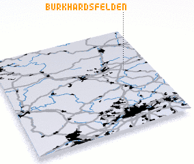 Places with similar names to Burkhardsfelden, Germany :: Disclaimer :: Information on this page comes without warranty of any kind |
||
|
Where is Burkhardsfelden? Elevation and coordinates ::
Latitude (lat): 50°35'0"N Longitude (lon): 8°49'0"E
Elevation (approx.): 219m (map arrows pan, magnifying glasses zoom) |
||
|
Visiting Burkhardsfelden? Hotel/Accommodation ::
Book a hotel in Burkhardsfelden Travel Guide ::
Buy a travel guide for Germany rental cars ::
car rental offers GPS waypoint ::
download a GPX waypoint (PoI) of Burkhardsfelden for your GPS receiver
|
||