|
search place name
|
||
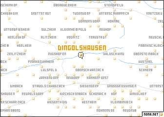
Dingolshausen (Bayern, Germany)Dingolshausen is a town in the Bayern region of Germany. An overview map of the region around Dingolshausen is displayed below.
regional and 3d topo map of Dingolshausen, Germany ::
Dingolshausen airports ::
The nearest airport is GHF - Giebelstadt Aaf, located 42.0 km south west of Dingolshausen.
Other airports nearby include NUE - Nuernberg Nurnberg (65.6 km south east), BYU - Bayreuth (89.4 km east), ZNF - Hanau Aaf (107.3 km west), HOQ - Hof Plauen (112.7 km north east), Nearby towns ::
Lisberg (1.9km south) //
Bischwind (1.9km north) //
Wiebelsberg (2.2km south west) //
Mutzenroth (3.7km south) //
Düttingsfeld (3.7km south) //
Michelau (2.4km east) //
Oberschwarzach (3.9km south) //
Bimbach (3.9km south) //
Vögnitz (3.9km north) //
Handthal (4.4km south east) //
Schallfeld (4.4km south west) //
Traustadt (4.4km north east) //
Altmannsdorf (4.4km north east) //
Hundelshausen (4.4km north east) //
Mönchstockheim (4.4km north west) //
Gerolzhofen (3.6km west) //
Rügshofen (3.6km west) //
Neudorf (5.7km south) //
Prüßberg (4.0km north east) //
Kleinrheinfeld (5.7km north) //
Kammerforst (6.1km south east) //
Breitbach (6.1km south east) //
Brünnau (5.2km south west) //
Waldschwind (4.8km east) //
Siegendorf (7.5km south) //
Donnersdorf (7.5km north) //
Heinachshof (5.1km east) //
Neuhausen (5.1km east) //
Neuhof (6.6km north east) //
[all distances 'as the bird flies' and approximate]  Places with similar names to Dingolshausen, Germany ::
// Dankelshausen (DE)
// Dinkelshausen (DE)
Disclaimer :: Information on this page comes without warranty of any kind |
||
|
Where is Dingolshausen? Elevation and coordinates ::
Latitude (lat): 49°54'0"N Longitude (lon): 10°24'0"E
Elevation (approx.): 285m (map arrows pan, magnifying glasses zoom) |
||
|
Visiting Dingolshausen? Hotel/Accommodation ::
Book a hotel in Dingolshausen Travel Guide ::
Buy a travel guide for Germany rental cars ::
car rental offers GPS waypoint ::
download a GPX waypoint (PoI) of Dingolshausen for your GPS receiver
|
||