|
search place name
|
||
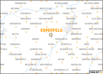
Espenfeld (Thüringen, Germany)Espenfeld is a town in the Thüringen region of Germany. An overview map of the region around Espenfeld is displayed below.
regional and 3d topo map of Espenfeld, Germany ::
Espenfeld airports ::
The nearest airport is ERF - Erfurt, located 18.6 km north of Espenfeld.
Other airports nearby include HOQ - Hof Plauen (89.6 km south east), BYU - Bayreuth (106.4 km south east), AOC - Altenburg Nobitz (114.5 km east), LEJ - Leipzig Halle (116.3 km north east), Nearby towns ::
Bittstädt (2.2km north west) //
Dosdorf (2.2km south east) //
Plaue (3.7km south) //
Siegelbach (3.0km south east) //
Holzhausen (3.9km north) //
Haarhausen (5.6km north) //
Längwitz (4.0km north east) //
Arnstadt (4.0km north east) //
Kleinbreitenbach (5.7km south) //
Gossel (4.0km south west) //
Wachsenburg (5.7km north) //
Rehestädt (5.7km north) //
Rippersroda (6.0km south west) //
Röhrensee (5.1km north west) //
Reinsfeld (5.1km south east) //
Sülzenbrücken (7.4km north) //
Angelhausen (5.0km east) //
Neusiß (7.5km south) //
Schmerfeld (6.6km south east) //
Liebenstein (6.6km south west) //
Angelroda (7.8km south) //
Rudisleben (6.0km north east) //
Thörey (8.2km north east) //
Kettmannshausen (7.3km south east) //
Arnshall (7.3km north east) //
Ichtershausen (8.8km north east) //
Wipfra (8.8km south east) //
[all distances 'as the bird flies' and approximate]  Places with similar names to Espenfeld, Germany :: Disclaimer :: Information on this page comes without warranty of any kind |
||
|
Where is Espenfeld? Elevation and coordinates ::
Latitude (lat): 50°49'0"N Longitude (lon): 10°54'0"E
Elevation (approx.): 385m (map arrows pan, magnifying glasses zoom) |
||
|
Visiting Espenfeld? Hotel/Accommodation ::
Book a hotel in Espenfeld Travel Guide ::
Buy a travel guide for Germany rental cars ::
car rental offers GPS waypoint ::
download a GPX waypoint (PoI) of Espenfeld for your GPS receiver
|
||