|
search place name
|
||
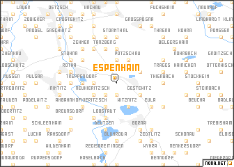
Espenhain (Sachsen, Germany)Espenhain is a town in the Sachsen region of Germany. An overview map of the region around Espenhain is displayed below.
regional and 3d topo map of Espenhain, Germany ::
Espenhain airports ::
The nearest airport is AOC - Altenburg Nobitz, located 22.6 km south of Espenhain.
Other airports nearby include LEJ - Leipzig Halle (31.8 km north west), DRS - Dresden (91.2 km east), ERF - Erfurt (108.1 km west), HOQ - Hof Plauen (108.5 km south west), Nearby towns ::
Kleinzössen (1.9km south) //
Hain (2.2km south west) //
Muckern (3.7km north) //
Dreiskau-Muckern (3.7km north) //
Dreiskau (3.7km north) //
Kreudnitz (2.3km west) //
Gestewitz (3.0km south east) //
Berghäuser (3.0km south east) //
Haubitz (3.9km south) //
Witznitz (3.9km south) //
Mölbis (3.0km north east) //
Großzössen (3.9km south) //
Dahlitzsch (3.9km north) //
Pötzschau (3.9km north) //
Kahnsdorf (3.0km south west) //
Neukieritzsch (3.0km south west) //
Zöpen (3.0km south west) //
Pürsten (3.0km south west) //
Rödgen (5.6km north) //
Trachenau (3.5km west) //
Treppendorf (3.5km west) //
Tanzberg (5.7km north) //
Magdeborn (5.7km north) //
Göltzschen (5.7km north) //
Lobstädt (5.7km south) //
Am Bahnhof Kieritzsch (5.1km south west) //
Eula (5.1km south east) //
Kesselshain (5.1km south east) //
Rüben (5.1km north west) //
[all distances 'as the bird flies' and approximate]  Places with similar names to Espenhain, Germany :: Disclaimer :: Information on this page comes without warranty of any kind |
||
|
Where is Espenhain? Elevation and coordinates ::
Latitude (lat): 51°11'0"N Longitude (lon): 12°28'0"E
Elevation (approx.): 157m (map arrows pan, magnifying glasses zoom) |
||
|
Visiting Espenhain? Hotel/Accommodation ::
Book a hotel in Espenhain Travel Guide ::
Buy a travel guide for Germany rental cars ::
car rental offers GPS waypoint ::
download a GPX waypoint (PoI) of Espenhain for your GPS receiver
|
||