|
search place name
|
||
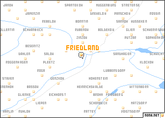
Friedland (Mecklenburg-Vorpommern, Germany)Friedland is a town in the Mecklenburg-Vorpommern region of Germany. An overview map of the region around Friedland is displayed below.
regional and 3d topo map of Friedland, Germany ::
Friedland airports ::
The nearest airport is RLG - Laage, located 87.8 km west of Friedland.
Other airports nearby include SZZ - Szczechin Goleniow (90.1 km east), SZW - Schwerin Parchim (120.5 km west), TXL - Berlin Tegel (126.3 km south), THF - Berlin Tempelhof (135.0 km south), Nearby towns ::
Kavelpaß (2.2km north east) //
Zinzow (3.7km north) //
Bornmühl (2.9km north east) //
Bresewitz (2.9km north west) //
Rubenow (5.6km north) //
Hohenstein (6.0km south) //
Borntin (7.4km north) //
Salow (4.4km west) //
Heinrichswalde (7.5km south) //
Pleetz (4.8km south west) //
Boldekow (6.5km north east) //
Genzkow (6.5km south west) //
Lübbersdorf (5.7km south east) //
Brohm (8.1km south east) //
Ramelow (7.1km north west) //
Rebelow (8.6km north west) //
[all distances 'as the bird flies' and approximate] 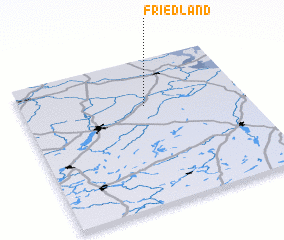 Places with similar names to Friedland, Germany ::
Disclaimer :: Information on this page comes without warranty of any kind |
||
|
Where is Friedland? Elevation and coordinates ::
Latitude (lat): 53°41'0"N Longitude (lon): 13°33'0"E
Elevation (approx.): 11m (map arrows pan, magnifying glasses zoom) |
||
|
Visiting Friedland? Hotel/Accommodation ::
Book a hotel in Friedland Travel Guide ::
Buy a travel guide for Germany rental cars ::
car rental offers GPS waypoint ::
download a GPX waypoint (PoI) of Friedland for your GPS receiver
|
||