|
search place name
|
||
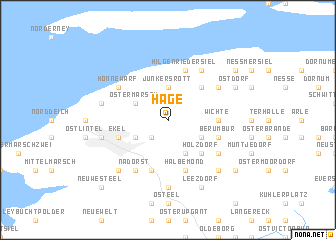
Hage (Niedersachsen, Germany)Hage is a town in the Niedersachsen region of Germany. An overview map of the region around Hage is displayed below.
regional and 3d topo map of Hage, Germany ::
Hage airports ::
The nearest airport is NRD - Norderney, located 10.3 km north of Hage.
Other airports nearby include EME - Emden (25.2 km south), BMK - Borkum (37.0 km west), WVN - Wilhelmshaven Mariensiel (53.6 km east), GRQ - Groningen Eelde (71.8 km south west), Nearby towns ::
Lütetsburg (2.2km south west) //
Junkersrott (3.7km north) //
Berum (2.9km south east) //
Ostermarsch (2.9km north west) //
Hagerwilde (3.9km south) //
Bargebur (2.9km south west) //
Hagermarsch (4.3km north east) //
Holzdorf (4.3km south east) //
Blandorf-Wichte (3.3km east) //
Blandorf (3.3km east) //
Wichte (3.3km east) //
Hilgenriedersiel (5.7km north) //
Halbemond (5.7km south) //
Ekel (3.8km south west) //
Berumbur (3.8km south east) //
Ekelergaste (3.8km south west) //
Süderneuland Zwei (5.7km south) //
Westdorf (5.0km north east) //
Honnewarf (5.0km north west) //
Theener (6.0km north) //
Kleinheide (5.0km south east) //
Nadörst (6.0km south) //
Schwee (7.4km south) //
Westerloog (4.8km north west) //
Osterloog (4.8km north west) //
Norden (4.8km south west) //
Wurzeldeich (6.5km south west) //
Westermoordorf (6.5km south east) //
Süderneuland Eins (6.5km south west) //
[all distances 'as the bird flies' and approximate] 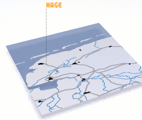 Places with similar names to Hage, Germany ::
Disclaimer :: Information on this page comes without warranty of any kind |
||
|
Where is Hage? Elevation and coordinates ::
Latitude (lat): 53°37'0"N Longitude (lon): 7°16'0"E
Elevation (approx.): 6m (map arrows pan, magnifying glasses zoom) |
||
|
Visiting Hage? Hotel/Accommodation ::
Book a hotel in Hage Travel Guide ::
Buy a travel guide for Germany rental cars ::
car rental offers GPS waypoint ::
download a GPX waypoint (PoI) of Hage for your GPS receiver
|
||