|
search place name
|
||
Hege (Bayern, Germany)Hege is a town in the Bayern region of Germany. An overview map of the region around Hege is displayed below.
regional and 3d topo map of Hege, Germany ::

Hege airports ::
The nearest airport is ACH - St Gallen Altenrhein, located 11.7 km south of Hege.
Other airports nearby include FDH - Friedrichshafen (12.6 km north west), ZRH - Zurich (81.5 km west), ZQL - Donaueschingen Villingen (92.8 km north west), SMV - Samedan (118.4 km south), Nearby towns ::
Hattnau (0.0km north) //
Selmnau (0.0km north) //
Retterschen (0.0km north) //
Nonnenhorn (0.0km north) //
Hengnau (1.3km east) //
Hüttmannsberg (1.9km north) //
Gottmannsbühl (1.9km north) //
Atlashofen (1.9km north) //
Gattnau (1.9km north) //
Mitten (2.2km south east) //
Mooslachen (2.2km south east) //
Wasserburg (2.2km south east) //
Nonnenhorn (2.2km south west) //
Kümmertsweiler (2.2km north east) //
Arensweiler (2.2km north east) //
Poppis (2.2km north east) //
Kressbronn am Bodensee (2.2km north west) //
Rickatshofen (2.5km east) //
Bruggach (2.5km east) //
Tunau (2.5km west) //
Unterwolfertsweiler (3.7km north) //
Reutinen (3.1km south east) //
Bichel (3.1km south east) //
Hochsträß (3.1km south east) //
Bettnau (3.1km south east) //
Lindenhof (3.1km south east) //
Wettis (3.1km north east) //
Hörbolz (3.1km north east) //
Bechtersweiler (3.1km north east) //
[all distances 'as the bird flies' and approximate] 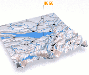 Places with similar names to Hege, Germany ::
Disclaimer :: Information on this page comes without warranty of any kind |
||
|
Where is Hege? Elevation and coordinates ::
Latitude (lat): 47°35'0"N Longitude (lon): 9°37'0"E
Elevation (approx.): 437m (map arrows pan, magnifying glasses zoom) |
||
|
Visiting Hege? Hotel/Accommodation ::
Book a hotel in Hege Travel Guide ::
Buy a travel guide for Germany rental cars ::
car rental offers GPS waypoint ::
download a GPX waypoint (PoI) of Hege for your GPS receiver
|
||