|
search place name
|
||
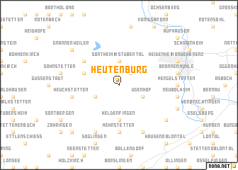
Heutenburg (Baden-Württemberg, Germany)Heutenburg is a town in the Baden-Württemberg region of Germany. An overview map of the region around Heutenburg is displayed below.
regional and 3d topo map of Heutenburg, Germany ::
Heutenburg airports ::
The nearest airport is STR - Stuttgart, located 62.4 km west of Heutenburg.
Other airports nearby include AGB - Augsburg (68.6 km east), FEL - Fuerstenfeldbruck Furstenfeldbruck (101.6 km south east), OBF - Oberpfaffenhofen (110.1 km south east), GHF - Giebelstadt Aaf (111.2 km north), Nearby towns ::
Küpfendorf (2.2km north east) //
Sontheim im Stubental (3.7km north) //
Klosterhof (3.7km north) //
Steinheim am Albuch (3.7km north) //
Ugenhof (3.1km south east) //
Gerstetten (3.1km south west) //
Heldenfingen (5.6km south) //
Dudelhof (4.1km north west) //
Neuselhalden (5.2km north west) //
Mehrstetten (7.4km south) //
Heuchstetten (5.2km west) //
Heuchlingen (7.8km south) //
Altheim (7.8km south) //
Dettingen am Albuch (7.4km south east) //
Gnannenweiler (7.4km north west) //
Königsbrunn (8.9km south west) //
[all distances 'as the bird flies' and approximate] 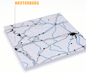 Places with similar names to Heutenburg, Germany ::
// Hüttenberg (CH)
// Haidenberg (AT)
// Hüttenberg (AT)
// Haddenberg (DE)
// Haidenberg (DE)
// Haidenburg (DE)
// Hattenburg (DE)
// Hodenberg (DE)
// Hüttenberg (DE)
// Hüttenberg (DE)
Disclaimer :: Information on this page comes without warranty of any kind |
||
|
Where is Heutenburg? Elevation and coordinates ::
Latitude (lat): 48°39'0"N Longitude (lon): 10°4'0"E
Elevation (approx.): 661m (map arrows pan, magnifying glasses zoom) |
||
|
Visiting Heutenburg? Hotel/Accommodation ::
Book a hotel in Heutenburg Travel Guide ::
Buy a travel guide for Germany rental cars ::
car rental offers GPS waypoint ::
download a GPX waypoint (PoI) of Heutenburg for your GPS receiver
|
||