|
search place name
|
||
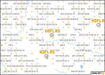
Höflas (Bayern, Germany)Höflas is a town in the Bayern region of Germany. An overview map of the region around Höflas is displayed below.
regional and 3d topo map of Höflas, Germany ::
Höflas airports ::
The nearest airport is BYU - Bayreuth, located 19.5 km north of Höflas.
Other airports nearby include HOQ - Hof Plauen (53.4 km north), NUE - Nuernberg Nurnberg (58.8 km south west), KLV - Karlovy Vary (96.0 km north east), GHF - Giebelstadt Aaf (127.6 km west), Nearby towns ::
Voita (0.0km north) //
Losau (1.9km north) //
Starkenacker (1.9km south) //
Kleinkorbis (2.2km north east) //
Menzlas (2.2km south east) //
Schlammersdorf (2.2km south east) //
Naslitz (2.2km south west) //
Vorbach (2.4km east) //
Bieberswöhr (2.4km west) //
Funkendorf (2.4km west) //
Frankenberg (3.9km north) //
Ernstfeld (3.0km south east) //
Unterschwarzach (3.9km north) //
Oberschwarzach (3.9km north) //
Prebitz (3.0km north west) //
Metzlasreuth (3.9km south) //
Sassenreuth (3.9km south) //
Kodlitz (4.4km north east) //
Nairitz (4.4km north east) //
Haar (4.4km south east) //
Seidwitz (4.4km north west) //
Heinersreuth (4.4km south west) //
Wölkersdorf (5.6km south) //
Pfaffenstetten (5.6km south) //
Burggrub (5.6km south) //
Altencreußen (3.6km west) //
Amoslohe (5.6km north) //
Preußling (4.0km north west) //
Tagmanns (5.7km south) //
[all distances 'as the bird flies' and approximate]  Places with similar names to Höflas, Germany ::
Disclaimer :: Information on this page comes without warranty of any kind |
||
|
Where is Höflas? Elevation and coordinates ::
Latitude (lat): 49°49'0"N Longitude (lon): 11°43'0"E
Elevation (approx.): 464m (map arrows pan, magnifying glasses zoom) |
||
|
Visiting Höflas? Hotel/Accommodation ::
Book a hotel in Höflas Travel Guide ::
Buy a travel guide for Germany rental cars ::
car rental offers GPS waypoint ::
download a GPX waypoint (PoI) of Höflas for your GPS receiver
|
||