|
search place name
|
||
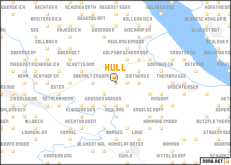
Hüll (Niedersachsen, Germany)Hüll is a town in the Niedersachsen region of Germany. An overview map of the region around Hüll is displayed below.
regional and 3d topo map of Hüll, Germany ::
Hüll airports ::
The nearest airport is XFW - Hamburg Finkenwerder, located 41.8 km south east of Hüll.
Other airports nearby include HAM - Hamburg (47.6 km east), BRV - Bremerhaven (52.5 km south west), BRE - Bremen (81.5 km south west), WVN - Wilhelmshaven Mariensiel (84.8 km west), Nearby towns ::
Gehrden (0.0km north) //
Oberhüll (1.1km east) //
Neustadt (1.1km east) //
Niederhüll (2.2km south west) //
Rönndeich (2.2km south west) //
Obenaltendorf (2.2km west) //
Im Horn (3.7km south) //
Sietwende (2.2km east) //
Wolfsbruchermoor (3.9km north) //
Großenwörden (3.9km south) //
Dornbuschermoor (2.9km north east) //
Neulandermoor (3.9km south) //
Strich (4.3km south west) //
Wolfsbruch (4.3km north east) //
Neuland (5.6km south) //
Schüttdamm (3.8km north west) //
Theisbrüggermoor (3.8km south east) //
Hamelwördenermoor (5.7km north) //
Neulandermoor (5.7km north) //
Neuland (5.0km north east) //
Schleusenfeld (5.0km south west) //
Kranenweide (4.4km west) //
Dösemoor (7.5km north) //
Dornbusch (4.8km north east) //
Wisch (7.5km south) //
Aschhorn (4.8km south east) //
Breitenwisch (7.5km south) //
Engelschoff (6.5km south east) //
Kleinwörden (6.5km south west) //
[all distances 'as the bird flies' and approximate]  Places with similar names to Hüll, Germany ::
Disclaimer :: Information on this page comes without warranty of any kind |
||
|
Where is Hüll? Elevation and coordinates ::
Latitude (lat): 53°43'0"N Longitude (lon): 9°17'0"E
Elevation (approx.): -3m (map arrows pan, magnifying glasses zoom) |
||
|
Visiting Hüll? Hotel/Accommodation ::
Book a hotel in Hüll Travel Guide ::
Buy a travel guide for Germany rental cars ::
car rental offers GPS waypoint ::
download a GPX waypoint (PoI) of Hüll for your GPS receiver
|
||