|
search place name
|
||
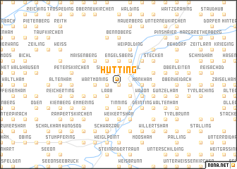
Hütting (Bayern, Germany)Hütting is a town in the Bayern region of Germany. An overview map of the region around Hütting is displayed below.
regional and 3d topo map of Hütting, Germany ::
Hütting airports ::
The nearest airport is SZG - Salzburg, located 46.8 km south east of Hütting.
Other airports nearby include MUC - Munich Munchen (64.2 km north west), OBF - Oberpfaffenhofen (94.4 km west), FEL - Fuerstenfeldbruck Furstenfeldbruck (96.4 km west), LNZ - Linz (Horsching) (123.0 km east), Nearby towns ::
Lohen (0.0km north) //
Tacherting (1.2km east) //
Pinzgau (1.2km west) //
Unterbrunnham (1.9km north) //
Oberbrunnham (1.9km north) //
Starfling (1.9km north) //
Laab (2.2km south west) //
Schalchen (2.2km south east) //
Schönreit (2.2km south west) //
Eberting (2.2km south west) //
Galgenpoint (2.2km south east) //
Lengloh (2.2km south east) //
Wiesmühl (2.2km north east) //
Schabing (2.2km north west) //
Gramsham (2.5km east) //
Mankham (2.5km east) //
Schörging (2.5km west) //
Schweinberg (2.5km west) //
Berg (2.5km west) //
Wartmoning (2.5km west) //
Perating (3.7km south) //
Tinning (3.7km south) //
Wölkham (3.7km north) //
Engelsberg (3.7km north) //
Wajon (3.1km south east) //
Biburg (3.1km south west) //
Feldkirchen (3.9km south) //
Mussenmühle (3.9km south) //
Mittermühle (3.9km south) //
[all distances 'as the bird flies' and approximate]  Places with similar names to Hütting, Germany ::
Disclaimer :: Information on this page comes without warranty of any kind |
||
|
Where is Hütting? Elevation and coordinates ::
Latitude (lat): 48°5'0"N Longitude (lon): 12°33'0"E
Elevation (approx.): 525m (map arrows pan, magnifying glasses zoom) |
||
|
Visiting Hütting? Hotel/Accommodation ::
Book a hotel in Hütting Travel Guide ::
Buy a travel guide for Germany rental cars ::
car rental offers GPS waypoint ::
download a GPX waypoint (PoI) of Hütting for your GPS receiver
|
||