|
search place name
|
||
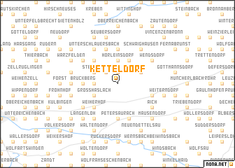
Ketteldorf (Bayern, Germany)Ketteldorf is a town in the Bayern region of Germany. An overview map of the region around Ketteldorf is displayed below.
regional and 3d topo map of Ketteldorf, Germany ::
Ketteldorf airports ::
The nearest airport is NUE - Nuernberg Nurnberg, located 28.3 km north east of Ketteldorf.
Other airports nearby include GHF - Giebelstadt Aaf (65.7 km north west), BYU - Bayreuth (95.4 km north east), AGB - Augsburg (103.7 km south), HOQ - Hof Plauen (131.2 km north east), Nearby towns ::
Höfstetten (1.9km north) //
Neuhöflein (2.2km north west) //
Hörleinsdorf (3.7km north) //
Markttriebendorf (3.7km north) //
Gleizendorf (2.4km west) //
Betzendorf (3.9km north) //
Bonnhof (3.0km north east) //
Steinbach (3.0km north west) //
Böllingsdorf (3.0km north east) //
Großhaslach (3.0km south west) //
Kehlmünz (4.4km north west) //
Weiherhof (4.4km south west) //
Münchzell (5.6km north) //
Bruckberg (3.6km west) //
Ziegendorf (5.6km south) //
Petersaurach (5.6km south) //
Lentersdorf (5.7km north) //
Heilsbronn (4.1km south east) //
Altendettelsau (5.7km south) //
Wendsdorf (5.2km north east) //
Großhabersdorf (6.1km north east) //
Herpersdorf (6.1km north west) //
Unterschlauersbach (6.1km north west) //
Bürglein (5.2km north east) //
Schwaighausen (6.1km north east) //
Rothleiten (6.1km north west) //
Kleinhaslach (5.2km north west) //
Vestenberg (5.2km south west) //
Aich (5.2km south east) //
[all distances 'as the bird flies' and approximate]  Places with similar names to Ketteldorf, Germany ::
Disclaimer :: Information on this page comes without warranty of any kind |
||
|
Where is Ketteldorf? Elevation and coordinates ::
Latitude (lat): 49°21'0"N Longitude (lon): 10°45'0"E
Elevation (approx.): 417m (map arrows pan, magnifying glasses zoom) |
||
|
Visiting Ketteldorf? Hotel/Accommodation ::
Book a hotel in Ketteldorf Travel Guide ::
Buy a travel guide for Germany rental cars ::
car rental offers GPS waypoint ::
download a GPX waypoint (PoI) of Ketteldorf for your GPS receiver
|
||