|
search place name
|
||
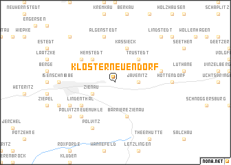
Kloster Neuendorf (Sachsen-Anhalt, Germany)Kloster Neuendorf is a town in the Sachsen-Anhalt region of Germany. An overview map of the region around Kloster Neuendorf is displayed below.
regional and 3d topo map of Kloster Neuendorf, Germany ::
Kloster Neuendorf airports ::
The nearest airport is BWE - Braunschweig Wolfsburg, located 66.4 km west of Kloster Neuendorf.
Other airports nearby include ZCN - Celle (98.2 km west), SZW - Schwerin Parchim (101.7 km north), HAJ - Hannover (121.3 km west), TXL - Berlin Tegel (123.6 km east), Nearby towns ::
Jävenitz (2.3km east) //
Zienau (2.9km south west) //
Trüstedt (4.3km north east) //
Hemstedt (4.3km north west) //
Kassieck (5.7km north) //
Barriere Zienau (5.7km south) //
Lindenthal (5.0km south west) //
Lüffingen (5.0km north west) //
Jäskau (4.9km east) //
Algenstedt (7.5km north) //
Polvitz-Neuemühle (6.5km south west) //
Polvitz (7.7km south) //
Waldschnibbe (5.8km south west) //
Kenzendorf (7.2km south west) //
Lindstedt (8.7km north east) //
Schenkenhorst (8.7km north west) //
[all distances 'as the bird flies' and approximate]  Places with similar names to Kloster Neuendorf, Germany ::
// Klosternaundorf (DE)
Disclaimer :: Information on this page comes without warranty of any kind |
||
|
Where is Kloster Neuendorf? Elevation and coordinates ::
Latitude (lat): 52°32'0"N Longitude (lon): 11°28'0"E
Elevation (approx.): 55m (map arrows pan, magnifying glasses zoom) |
||
|
Visiting Kloster Neuendorf? Hotel/Accommodation ::
Book a hotel in Kloster Neuendorf Travel Guide ::
Buy a travel guide for Germany rental cars ::
car rental offers GPS waypoint ::
download a GPX waypoint (PoI) of Kloster Neuendorf for your GPS receiver
|
||