|
search place name
|
||
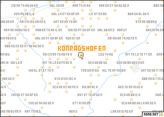
Konradshofen (Bayern, Germany)Konradshofen is a town in the Bayern region of Germany. An overview map of the region around Konradshofen is displayed below.
regional and 3d topo map of Konradshofen, Germany ::
Konradshofen airports ::
The nearest airport is AGB - Augsburg, located 32.6 km north east of Konradshofen.
Other airports nearby include FEL - Fuerstenfeldbruck Furstenfeldbruck (45.9 km east), OBF - Oberpfaffenhofen (48.9 km east), MUC - Munich Munchen (86.0 km east), FDH - Friedrichshafen (103.4 km south west), Nearby towns ::
Berghöfe (NaNkm north) //
Hilpoldsberg (1.9km north) //
Erkhausen (1.2km west) //
Birkach (2.2km north east) //
Rielhofen (2.2km north west) //
Scherstetten (2.2km south west) //
Köpfingerhof (2.5km west) //
Münster (3.9km north) //
Klimmach (3.1km north east) //
Kelchsried (3.1km north west) //
Grimoldsried (3.1km north west) //
Schwabegg (3.1km south east) //
Forsthofen (3.9km south) //
Traunried (3.9km south) //
Aletshofen (4.5km south east) //
Höfen (4.5km south east) //
Laiber (5.6km north) //
Todtenschläule (5.6km north) //
Siegertshofen (5.6km north) //
Leuthau (3.7km east) //
Königshausen (3.7km east) //
Reichertshofen (3.7km west) //
Mickhausen (5.7km north) //
Mittelneufnach (4.1km south west) //
Kirch Siebnach (5.7km south) //
Oberrothan (5.2km north west) //
Steinekirch (6.1km south west) //
Tronetshofen (7.4km north) //
Lutzenberg (4.9km west) //
[all distances 'as the bird flies' and approximate]  Places with similar names to Konradshofen, Germany ::
// Gannertshofen (DE)
Disclaimer :: Information on this page comes without warranty of any kind |
||
|
Where is Konradshofen? Elevation and coordinates ::
Latitude (lat): 48°12'0"N Longitude (lon): 10°39'0"E
Elevation (approx.): 541m (map arrows pan, magnifying glasses zoom) |
||
|
Visiting Konradshofen? Hotel/Accommodation ::
Book a hotel in Konradshofen Travel Guide ::
Buy a travel guide for Germany rental cars ::
car rental offers GPS waypoint ::
download a GPX waypoint (PoI) of Konradshofen for your GPS receiver
|
||