|
search place name
|
||
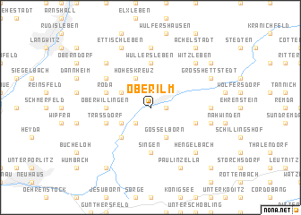
Oberilm (Thüringen, Germany)Oberilm is a town in the Thüringen region of Germany. An overview map of the region around Oberilm is displayed below.
regional and 3d topo map of Oberilm, Germany ::
Oberilm airports ::
The nearest airport is ERF - Erfurt, located 24.9 km north of Oberilm.
Other airports nearby include HOQ - Hof Plauen (77.1 km south east), BYU - Bayreuth (96.1 km south east), AOC - Altenburg Nobitz (104.1 km east), LEJ - Leipzig Halle (110.7 km north east), Nearby towns ::
Stadtilm (1.2km east) //
Griesheim (2.2km south west) //
Hammersfeld (2.2km south west) //
Hoheskreuz (3.9km north) //
Niederwillingen (3.0km north west) //
Geilsdorf (3.9km south) //
Gösselborn (3.9km south) //
Cottendorf (3.0km south west) //
Dörnfeld an der Ilm (4.4km south west) //
Wüllersleben (5.6km north) //
Oberwillingen (3.5km west) //
Singen (5.6km south) //
Roda (4.0km north west) //
Behringen (4.0km north west) //
Großliebringen (4.0km south east) //
Traßdorf (4.0km south west) //
Görbitzhausen (5.1km north west) //
Bösleben-Wüllersleben (7.4km north) //
Bösleben (7.4km north) //
Döllstedt (4.7km east) //
Kleinliebringen (5.0km east) //
Witzleben (6.6km north east) //
Hausen (6.6km north west) //
Marlishausen (6.6km north west) //
Hengelbach (6.6km south east) //
Großhettstedt (6.0km north east) //
Ettischleben (7.8km north) //
Paulinzella (7.8km south) //
Achelstädt (8.2km north east) //
[all distances 'as the bird flies' and approximate] 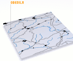 Places with similar names to Oberilm, Germany ::
Disclaimer :: Information on this page comes without warranty of any kind |
||
|
Where is Oberilm? Elevation and coordinates ::
Latitude (lat): 50°46'0"N Longitude (lon): 11°4'0"E
Elevation (approx.): 366m (map arrows pan, magnifying glasses zoom) |
||
|
Visiting Oberilm? Hotel/Accommodation ::
Book a hotel in Oberilm Travel Guide ::
Buy a travel guide for Germany rental cars ::
car rental offers GPS waypoint ::
download a GPX waypoint (PoI) of Oberilm for your GPS receiver
|
||