|
search place name
|
||
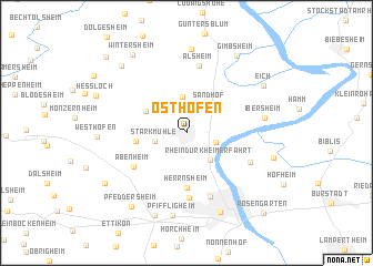
Osthofen (Rheinland-Pfalz, Germany)Osthofen is a town in the Rheinland-Pfalz region of Germany. An overview map of the region around Osthofen is displayed below.
regional and 3d topo map of Osthofen, Germany ::
Osthofen airports ::
The nearest airport is MHG - Mannheim City, located 29.4 km south east of Osthofen.
Other airports nearby include FRA - Frankfurt Main (38.6 km north east), ZQC - Speyer (45.9 km south), RMS - Ramstein Ab (60.7 km south west), ZNF - Hanau Aaf (68.5 km north east), Nearby towns ::
Rheindürkheim (2.1km south east) //
Stärkmühle (2.3km south west) //
Rhein-Dürkheimer Fahrt (3.1km south east) //
Mettenheim (3.6km north) //
Sandhof (3.2km north east) //
Bechtheim (3.4km north west) //
Mühlheim (3.4km west) //
Herrnsheim (5.5km south) //
Abenheim (4.8km south west) //
Hochheim (6.5km south) //
Alsheim (6.8km north) //
Neuhausen (6.6km south) //
Nordheim (5.1km south east) //
Ibersheim (5.3km east) //
Pfiffligheim (8.3km south) //
Hangen Wahlheim (8.4km north) //
Worms (8.3km south) //
Leiselheim (8.5km south) //
Eich (6.9km north east) //
Wattenheim (6.2km south east) //
Pfeddersheim (8.3km south west) //
Gimbsheim (8.5km north east) //
Dorn-Dürkheim (8.0km north west) //
Wintersheim (8.6km north west) //
Mörstadt (7.4km south west) //
Hillesheim (9.2km north west) //
Rosengarten (9.5km south east) //
[all distances 'as the bird flies' and approximate]  Places with similar names to Osthofen, Germany ::
Disclaimer :: Information on this page comes without warranty of any kind |
||
|
Where is Osthofen? Elevation and coordinates ::
Latitude (lat): 49°42'28"N Longitude (lon): 8°19'44"E
Elevation (approx.): 95m (map arrows pan, magnifying glasses zoom) |
||
|
Visiting Osthofen? Hotel/Accommodation ::
Book a hotel in Osthofen Travel Guide ::
Buy a travel guide for Germany rental cars ::
car rental offers GPS waypoint ::
download a GPX waypoint (PoI) of Osthofen for your GPS receiver
|
||