|
search place name
|
||
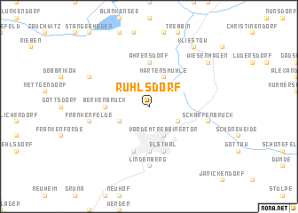
Ruhlsdorf (Brandenburg, Germany)Ruhlsdorf is a town in the Brandenburg region of Germany. An overview map of the region around Ruhlsdorf is displayed below.
regional and 3d topo map of Ruhlsdorf, Germany ::
Ruhlsdorf airports ::
The nearest airport is SXF - Berlin Schonefeld, located 36.7 km north east of Ruhlsdorf.
Other airports nearby include THF - Berlin Tempelhof (41.1 km north east), TXL - Berlin Tegel (48.2 km north), LEJ - Leipzig Halle (100.8 km south west), DRS - Dresden (118.8 km south), Nearby towns ::
Vor dem Trebbiner Tor (3.9km south) //
Woltersdorf (2.9km south east) //
Liebätz (2.9km north east) //
Neufrankenfelde (2.9km south west) //
Märtensmühle (3.9km north) //
Luckenwalde (5.6km south) //
Vor dem Jüterborger Tor (5.6km south) //
Berkenbrück (3.4km west) //
Ahrensdorf (5.6km north) //
Elsthal (5.7km south) //
Vor dem Baruther Tor (5.7km south) //
Weinberge (5.7km south) //
Kolzenburg (7.4km south) //
Lindenberg (7.4km south) //
Scharfenbrück (4.9km east) //
Frankenfelde (4.9km west) //
Hennickendorf (5.9km north west) //
Wiesenhagen (7.2km north east) //
Kliestow (8.2km north east) //
[all distances 'as the bird flies' and approximate]  Places with similar names to Ruhlsdorf, Germany ::
Disclaimer :: Information on this page comes without warranty of any kind |
||
|
Where is Ruhlsdorf? Elevation and coordinates ::
Latitude (lat): 52°8'0"N Longitude (lon): 13°10'0"E
Elevation (approx.): 54m (map arrows pan, magnifying glasses zoom) |
||
|
Visiting Ruhlsdorf? Hotel/Accommodation ::
Book a hotel in Ruhlsdorf Travel Guide ::
Buy a travel guide for Germany rental cars ::
car rental offers GPS waypoint ::
download a GPX waypoint (PoI) of Ruhlsdorf for your GPS receiver
|
||