|
search place name
|
||
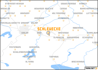
Schlewecke (Niedersachsen, Germany)Schlewecke is a town in the Niedersachsen region of Germany. An overview map of the region around Schlewecke is displayed below.
regional and 3d topo map of Schlewecke, Germany ::
Schlewecke airports ::
The nearest airport is BWE - Braunschweig Wolfsburg, located 46.7 km north of Schlewecke.
Other airports nearby include ZCN - Celle (84.0 km north west), HAJ - Hannover (84.5 km north west), KSF - Kassel Calden (95.9 km south west), ERF - Erfurt (106.9 km south), Nearby towns ::
Göttingerode (0.0km north) //
Blöcktach (1.9km south) //
Harlingerode (1.9km north) //
Mathildenhütte (2.3km east) //
Oker (2.3km west) //
Elfenecke (2.9km south east) //
Bündheim (2.9km south east) //
Westerode (3.4km east) //
Bad Harzburg (3.9km south east) //
Ohlhof (5.0km north west) //
Immenrode (6.0km north) //
Bettingerode (4.6km east) //
Gemkental (6.5km south west) //
Vienenburg (6.5km north east) //
Wöltingerode (7.8km north) //
Wiedelah (8.7km north east) //
[all distances 'as the bird flies' and approximate]  Places with similar names to Schlewecke, Germany ::
// Schlewecke (DE)
// Sokołówek (PL)
Disclaimer :: Information on this page comes without warranty of any kind |
||
|
Where is Schlewecke? Elevation and coordinates ::
Latitude (lat): 51°54'0"N Longitude (lon): 10°31'0"E
Elevation (approx.): 278m (map arrows pan, magnifying glasses zoom) |
||
|
Visiting Schlewecke? Hotel/Accommodation ::
Book a hotel in Schlewecke Travel Guide ::
Buy a travel guide for Germany rental cars ::
car rental offers GPS waypoint ::
download a GPX waypoint (PoI) of Schlewecke for your GPS receiver
|
||