|
search place name
|
||
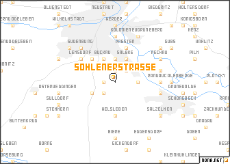
Sohlener Straße (Sachsen-Anhalt, Germany)Sohlener Straße is a town in the Sachsen-Anhalt region of Germany. An overview map of the region around Sohlener Straße is displayed below.
regional and 3d topo map of Sohlener Straße, Germany ::
Sohlener Straße airports ::
The nearest airport is LEJ - Leipzig Halle, located 79.9 km south east of Sohlener Straße.
Other airports nearby include BWE - Braunschweig Wolfsburg (80.6 km west), TXL - Berlin Tegel (125.3 km north east), ZCN - Celle (126.3 km north west), ERF - Erfurt (128.4 km south), Nearby towns ::
Beyendorf (1.1km west) //
Wolfsfelde (1.9km north) //
Sohlen (2.2km south west) //
Westerhüsen (2.2km north east) //
Malpendorf (2.3km east) //
Fermersleben (3.7km north) //
Gartenstadt Lüttgensalbke (3.7km north) //
Dodendorf (2.9km south west) //
Buckau (3.9km north) //
Salbke (3.9km north) //
Gartenstadt Hopfengarten (4.4km north west) //
Welsleben (5.6km south) //
Prester (5.7km north) //
Lemsdorf (5.0km north west) //
Randau (4.6km east) //
Brückfeld (7.4km north) //
Frohse (4.9km east) //
Calenberge (4.9km east) //
Sudenburg (6.5km north west) //
Pechau (5.9km north east) //
Kolonie Neu Grüneberg (7.8km north) //
Salzelmen (7.2km south east) //
Zipkeleben (7.2km north east) //
Ottersleben (7.2km north west) //
[all distances 'as the bird flies' and approximate]  Places with similar names to Sohlener Straße, Germany :: Disclaimer :: Information on this page comes without warranty of any kind |
||
|
Where is Sohlener Straße? Elevation and coordinates ::
Latitude (lat): 52°3'0"N Longitude (lon): 11°39'0"E
Elevation (approx.): 67m (map arrows pan, magnifying glasses zoom) |
||
|
Visiting Sohlener Straße? Hotel/Accommodation ::
Book a hotel in Sohlener Straße Travel Guide ::
Buy a travel guide for Germany rental cars ::
car rental offers GPS waypoint ::
download a GPX waypoint (PoI) of Sohlener Straße for your GPS receiver
|
||