|
search place name
|
||
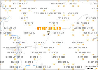
Steinweiler (Baden-Württemberg, Germany)Steinweiler is a town in the Baden-Württemberg region of Germany. An overview map of the region around Steinweiler is displayed below.
regional and 3d topo map of Steinweiler, Germany ::
Steinweiler airports ::
The nearest airport is AGB - Augsburg, located 59.9 km south east of Steinweiler.
Other airports nearby include STR - Stuttgart (77.0 km west), FEL - Fuerstenfeldbruck Furstenfeldbruck (94.4 km south east), NUE - Nuernberg Nurnberg (103.2 km north east), GHF - Giebelstadt Aaf (104.1 km north), Nearby towns ::
Kleinkuchen (1.2km west) //
Auernheim (2.4km east) //
Stetten (3.9km north) //
Großkuchen (3.1km north west) //
Fleinheim (4.4km south east) //
Nattheim (4.4km south west) //
Wahlberg (5.6km south) //
Elchingen auf dem Härtsfeld (7.4km north) //
Rotensohl (4.9km west) //
Staufen (7.5km south) //
Dossingen (6.7km north east) //
Oggenhausen (7.8km south) //
Nietheim (6.1km north west) //
Zöschingen (8.3km south east) //
Dorfmerkingen (8.3km north east) //
Weilermerkingen (8.9km north east) //
[all distances 'as the bird flies' and approximate]  Places with similar names to Steinweiler, Germany ::
Disclaimer :: Information on this page comes without warranty of any kind |
||
|
Where is Steinweiler? Elevation and coordinates ::
Latitude (lat): 48°44'0"N Longitude (lon): 10°16'0"E
Elevation (approx.): 567m (map arrows pan, magnifying glasses zoom) |
||
|
Visiting Steinweiler? Hotel/Accommodation ::
Book a hotel in Steinweiler Travel Guide ::
Buy a travel guide for Germany rental cars ::
car rental offers GPS waypoint ::
download a GPX waypoint (PoI) of Steinweiler for your GPS receiver
|
||