|
search place name
|
||
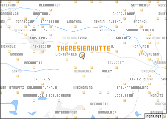
Theresienhütte (Brandenburg, Germany)Theresienhütte is a town in the Brandenburg region of Germany. An overview map of the region around Theresienhütte is displayed below.
regional and 3d topo map of Theresienhütte, Germany ::
Theresienhütte airports ::
The nearest airport is DRS - Dresden, located 52.0 km south of Theresienhütte.
Other airports nearby include BBJ - Bautzen (67.5 km south east), SXF - Berlin Schonefeld (88.9 km north), THF - Berlin Tempelhof (100.9 km north), LEJ - Leipzig Halle (109.8 km west), Nearby towns ::
Klingmühl (2.2km south east) //
Buschmühle (2.2km south west) //
Lieskau (2.2km north east) //
Lichterfeld (2.3km west) //
Lichterfelder Pechhütte (3.7km south) //
Bergheide (3.7km south) //
Siedlung Erika (3.9km north) //
Schacksdorf (3.0km north west) //
Betten (4.4km north west) //
Zürchel (3.9km north east) //
Poley (5.1km south east) //
Wischgrund (7.4km south) //
Lindthal (7.5km north) //
Sallgast (5.0km east) //
Dollenchen (5.0km east) //
Weinberg (6.5km north east) //
Rehain (7.8km north) //
Kostebrau (7.8km south) //
Grube Alwine (8.2km south east) //
Massen (7.2km north west) //
Rutzkau (8.7km north east) //
Tanneberg (8.7km north west) //
[all distances 'as the bird flies' and approximate]  Places with similar names to Theresienhütte, Germany :: Disclaimer :: Information on this page comes without warranty of any kind |
||
|
Where is Theresienhütte? Elevation and coordinates ::
Latitude (lat): 51°36'0"N Longitude (lon): 13°48'0"E
Elevation (approx.): 146m (map arrows pan, magnifying glasses zoom) |
||
|
Visiting Theresienhütte? Hotel/Accommodation ::
Book a hotel in Theresienhütte Travel Guide ::
Buy a travel guide for Germany rental cars ::
car rental offers GPS waypoint ::
download a GPX waypoint (PoI) of Theresienhütte for your GPS receiver
|
||