|
search place name
|
||
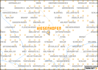
Wiesenhofen (Baden-Württemberg, Germany)Wiesenhofen is a town in the Baden-Württemberg region of Germany. An overview map of the region around Wiesenhofen is displayed below.
regional and 3d topo map of Wiesenhofen, Germany ::
Wiesenhofen airports ::
The nearest airport is FDH - Friedrichshafen, located 21.9 km south of Wiesenhofen.
Other airports nearby include ACH - St Gallen Altenrhein (42.4 km south), ZQL - Donaueschingen Villingen (77.7 km west), ZRH - Zurich (87.4 km south west), STR - Stuttgart (94.7 km north), Nearby towns ::
Wielatsried (0.0km north) //
Schreckensee (1.9km north) //
Grünlingen (1.9km north) //
Ried (1.2km west) //
Einöde (1.2km east) //
Geratsreute (1.2km west) //
Hochstett (1.9km south) //
Möllenbronn (2.2km north west) //
Kellenried (2.2km south east) //
Baienbach (2.2km south east) //
Dietenhofen (2.2km south east) //
Ingenhard (3.7km north) //
Malmishaus (3.7km north) //
Blitzenreute (2.5km east) //
Fronhofen (2.5km west) //
Reute bei Fronhofen (2.5km west) //
Ramsee (3.7km south) //
Stauden (3.7km south) //
Baien (3.7km south) //
Vorsee (3.1km north east) //
Ruprechtsbruck (3.1km north west) //
Ergetsweiler (3.1km south west) //
Hübschenberg (3.9km south) //
Ebenweiler (4.5km north west) //
Aichach (4.5km south east) //
Furt (4.5km south west) //
Oberschoren (4.5km south west) //
Oberwaldhausen (4.5km south west) //
Mendelbeuren (5.6km north) //
[all distances 'as the bird flies' and approximate]  Places with similar names to Wiesenhofen, Germany ::
// Waizenhofen (DE)
// Wiesenhofen (DE)
Disclaimer :: Information on this page comes without warranty of any kind |
||
|
Where is Wiesenhofen? Elevation and coordinates ::
Latitude (lat): 47°52'0"N Longitude (lon): 9°33'0"E
Elevation (approx.): 576m (map arrows pan, magnifying glasses zoom) |
||
|
Visiting Wiesenhofen? Hotel/Accommodation ::
Book a hotel in Wiesenhofen Travel Guide ::
Buy a travel guide for Germany rental cars ::
car rental offers GPS waypoint ::
download a GPX waypoint (PoI) of Wiesenhofen for your GPS receiver
|
||