|
search place name
|
||
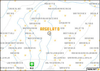
Argelato (Italy)Argelato is a town in Italy. An overview map of the region around Argelato is displayed below.
regional and 3d topo map of Argelato, Italy ::
Argelato airports ::
The nearest airport is BLQ - Bologna, located 11.9 km south west of Argelato.
Other airports nearby include FRL - Forli (75.3 km south east), PMF - Parma (86.1 km west), VRN - Villafranca (92.2 km north west), FLR - Firenze (92.2 km south), Nearby towns ::
Stiatico (2.3km south east) //
San Giorgio di Piano (2.3km north east) //
Bonconvento (4.4km south west) //
Santa Maria di Venezzano (5.7km north) //
Casa delle Curve (6.2km south west) //
Gherghenzano (6.2km north east) //
San Donino (5.4km north west) //
Cinquanta (5.4km north east) //
Padulle (5.3km west) //
Bentivoglio (5.3km east) //
Castel Maggiore (7.5km south) //
San Marino (5.6km east) //
Bagno di Piano (5.6km west) //
Castello dʼArgile (6.8km north west) //
San Marco (6.4km south east) //
Casa Donini (7.7km south west) //
Osteriola (7.7km south east) //
San Pietro in Casale (8.4km north east) //
[all distances 'as the bird flies' and approximate] 
Disclaimer :: Information on this page comes without warranty of any kind |
||
|
Where is Argelato? Elevation and coordinates ::
Latitude (lat): 44°38'0"N Longitude (lon): 11°21'0"E
Elevation (approx.): 21m (map arrows pan, magnifying glasses zoom) |
||
|
Visiting Argelato? Hotel/Accommodation ::
Book a hotel in Argelato Travel Guide ::
Buy a travel guide for Italy rental cars ::
car rental offers GPS waypoint ::
download a GPX waypoint (PoI) of Argelato for your GPS receiver
|
||