|
search place name
|
||
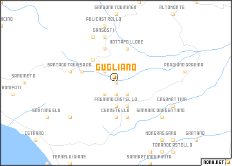
Gugliano (Italy)Gugliano is a town in Italy. An overview map of the region around Gugliano is displayed below.
regional and 3d topo map of Gugliano, Italy ::
Gugliano airports ::
The nearest airport is SUF - Lamezia Terme, located 78.9 km south of Gugliano.
Other airports nearby include CRV - Crotone (111.2 km south east), TAR - Grottaglie (154.0 km north east), REG - Reggio Calabria (173.2 km south), BRI - Bari (181.2 km north), Nearby towns ::
Malvito (0.0km north) //
San Pantaleo (1.9km south) //
Santa Caterina Albanese (2.3km south east) //
Il Seduttore (2.3km north west) //
Viziole (2.3km south west) //
Fagnano Castello (3.7km south) //
Ioggi (4.0km south) //
Capi dʼAcqua (4.7km north west) //
Cerretella (5.6km south) //
Mottafollone (5.7km north) //
Piano della Fiera (5.7km north) //
Camarella (4.7km north west) //
San Lauro (5.7km south) //
San Sosti (7.5km north) //
SantʼAgata di Esaro (6.0km west) //
Mecarillo (7.9km north) //
San Marco Argentano (8.0km south east) //
Cervicati (8.0km south east) //
Mio Caro (8.0km south west) //
[all distances 'as the bird flies' and approximate]  Places with similar names to Gugliano, Italy ::
Disclaimer :: Information on this page comes without warranty of any kind |
||
|
Where is Gugliano? Elevation and coordinates ::
Latitude (lat): 39°36'0"N Longitude (lon): 16°3'0"E
Elevation (approx.): 343m (map arrows pan, magnifying glasses zoom) |
||
|
Visiting Gugliano? Hotel/Accommodation ::
Book a hotel in Gugliano Travel Guide ::
Buy a travel guide for Italy rental cars ::
car rental offers GPS waypoint ::
download a GPX waypoint (PoI) of Gugliano for your GPS receiver
|
||