|
search place name
|
||
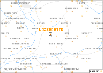
Lazzeretto (Italy)Lazzeretto is a town in Italy. An overview map of the region around Lazzeretto is displayed below.
regional and 3d topo map of Lazzeretto, Italy ::
Lazzeretto airports ::
The nearest airport is FLR - Firenze, located 27.4 km east of Lazzeretto.
Other airports nearby include PSA - Pisa (39.7 km west), SAY - Siena Ampugnano (66.4 km south east), BLQ - Bologna (90.1 km north), FRL - Forli (106.8 km north east), Nearby towns ::
Toiano (1.3km east) //
Cerreto Guidi (3.9km south) //
Ponte di Masino (4.6km north west) //
Puntoni (4.6km north west) //
Cecina (5.6km north) //
Vinci (4.0km east) //
Lamporecchio (5.7km north) //
Stabbia (4.4km north west) //
Fornello (5.5km north east) //
SantʼAnsano (5.7km east) //
Marcignana (7.5km south) //
Gavena (7.5km south) //
San Baronto (6.9km north east) //
Fucecchio (7.7km south west) //
[all distances 'as the bird flies' and approximate]  Places with similar names to Lazzeretto, Italy ::
// Lazareto (PH)
// Lizard (US)
// Lasarat (ET)
// Lazzaretto (IT)
// Lazareto (PT)
// La Sierrita (CU)
// La Suerte (CU)
// Lazarat (AL)
// Lazaret (RO)
// Lasarte (ES)
Disclaimer :: Information on this page comes without warranty of any kind |
||
|
Where is Lazzeretto? Elevation and coordinates ::
Latitude (lat): 43°47'0"N Longitude (lon): 10°52'0"E
Elevation (approx.): 36m (map arrows pan, magnifying glasses zoom) |
||
|
Visiting Lazzeretto? Hotel/Accommodation ::
Book a hotel in Lazzeretto Travel Guide ::
Buy a travel guide for Italy rental cars ::
car rental offers GPS waypoint ::
download a GPX waypoint (PoI) of Lazzeretto for your GPS receiver
|
||