|
search place name
|
||
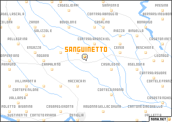
Sanguinetto (Italy)Sanguinetto is a town in Italy. An overview map of the region around Sanguinetto is displayed below.
regional and 3d topo map of Sanguinetto, Italy ::
Sanguinetto airports ::
The nearest airport is VRN - Villafranca, located 31.3 km north west of Sanguinetto.
Other airports nearby include VIC - Vicenza (52.6 km north east), QPA - Padova (59.6 km north east), VBS - Montichiari (69.8 km north west), BLQ - Bologna (72.8 km south), Nearby towns ::
Il Capitello (2.3km north west) //
Contrada Ronchiel (3.9km north) //
Casaleone (4.3km south east) //
Bionde di Visegna (4.3km north west) //
Maccacari (5.7km south) //
Campalano (5.5km west) //
Bonavicina (7.5km north) //
Cerea (5.5km east) //
Correzzo (6.8km south west) //
Casalino (7.9km north) //
Bovolone (7.9km north) //
Ca del Lago (6.4km north east) //
Corte Carpania (8.4km south east) //
Piazza (7.6km north east) //
[all distances 'as the bird flies' and approximate]  Places with similar names to Sanguinetto, Italy ::
// Xankǝndi (AZ)
// Xankǝndi (AZ)
// Cinquanta (IT)
// Sanguineto (IT)
// Sangoñedo (ES)
// Sanguiñeda (ES)
// Sanguiñedo (ES)
// Sanguñedo (ES)
// Sengānti (BD)
// Sonāikāndi (BD)
Disclaimer :: Information on this page comes without warranty of any kind |
||
|
Where is Sanguinetto? Elevation and coordinates ::
Latitude (lat): 45°11'0"N Longitude (lon): 11°9'0"E
Elevation (approx.): 18m (map arrows pan, magnifying glasses zoom) |
||
|
Visiting Sanguinetto? Hotel/Accommodation ::
Book a hotel in Sanguinetto Travel Guide ::
Buy a travel guide for Italy rental cars ::
car rental offers GPS waypoint ::
download a GPX waypoint (PoI) of Sanguinetto for your GPS receiver
|
||