|
search place name
|
||
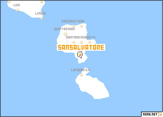
San Salvatore (Italy)San Salvatore is a town in Italy. An overview map of the region around San Salvatore is displayed below.
regional and 3d topo map of San Salvatore, Italy ::
San Salvatore airports ::
The nearest airport is REG - Reggio Calabria, located 74.4 km south east of San Salvatore.
Other airports nearby include CTA - Catania Fontanarossa (109.6 km south), NSY - Sigonella (116.4 km south), SUF - Lamezia Terme (123.3 km north east), PMO - Palermo Boccadifalco (148.1 km west), Nearby towns ::
Lipari (1.9km north) //
Marina (1.9km north) //
Santa Margherita (3.7km north) //
La Fabbrica (3.7km south) //
Canneto (4.0km north) //
Piano Conte (4.0km north) //
Quattro Pani (6.3km north west) //
Acquacalda (7.4km north) //
Chiesa Vetusa (7.6km north) //
[all distances 'as the bird flies' and approximate] 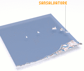 Places with similar names to San Salvatore, Italy ::
// San Salvatore (IT)
// San Salvatore (IT)
// San Salvatore (IT)
// San Salvatore (IT)
// San Salvador (CU)
// San Salvador (CU)
// San Salvador (CU)
// San Salvador (CU)
// San Salvador (CU)
// San Salvador (ES)
Disclaimer :: Information on this page comes without warranty of any kind |
||
|
Where is San Salvatore? Elevation and coordinates ::
Latitude (lat): 38°27'0"N Longitude (lon): 14°57'0"E
Elevation (approx.): 183m (map arrows pan, magnifying glasses zoom) |
||
|
Visiting San Salvatore? Hotel/Accommodation ::
Book a hotel in San Salvatore Travel Guide ::
Buy a travel guide for Italy rental cars ::
car rental offers GPS waypoint ::
download a GPX waypoint (PoI) of San Salvatore for your GPS receiver
|
||