|
search place name
|
||
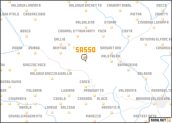
Sasso (Italy)Sasso is a town in Italy. An overview map of the region around Sasso is displayed below.
regional and 3d topo map of Sasso, Italy ::
Sasso airports ::
The nearest airport is VIC - Vicenza, located 31.2 km south of Sasso.
Other airports nearby include TSF - Treviso (51.4 km south east), QPA - Padova (54.1 km south), VCE - Venice Venezia Tessera (70.0 km south east), BZO - Bolzano (71.0 km north), Nearby towns ::
Stoccareddo (1.9km north) //
Campo di Mezza Via (3.2km south west) //
Ronchi (4.5km north west) //
Valstagna (3.9km east) //
Conco (5.6km south) //
Casa Meletta Davanti (5.7km north) //
Bertigo (4.3km north west) //
San Gaetano (4.3km north east) //
Gallio (5.4km north west) //
Foza (6.1km north east) //
Malga Lora (7.4km north) //
Oliero (5.2km east) //
Pra di Sotto (7.5km south) //
Lusiana (7.9km south) //
Malga Granezza di Gallia (6.4km south west) //
Stonar (8.4km north east) //
[all distances 'as the bird flies' and approximate] 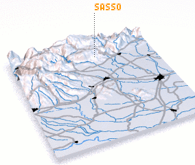 Places with similar names to Sasso, Italy ::
Disclaimer :: Information on this page comes without warranty of any kind |
||
|
Where is Sasso? Elevation and coordinates ::
Latitude (lat): 45°51'0"N Longitude (lon): 11°36'0"E
Elevation (approx.): 1044m (map arrows pan, magnifying glasses zoom) |
||
|
Visiting Sasso? Hotel/Accommodation ::
Book a hotel in Sasso Travel Guide ::
Buy a travel guide for Italy rental cars ::
car rental offers GPS waypoint ::
download a GPX waypoint (PoI) of Sasso for your GPS receiver
|
||