|
search place name
|
||
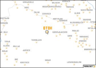
Otok (Cankova-Tišina, Slovenia)Otok is a town in the Cankova-Tišina region of Slovenia. An overview map of the region around Otok is displayed below.
regional and 3d topo map of Otok, Slovenia ::
Otok airports ::
The nearest airport is LJU - Ljubliana Ljubljana, located 55.4 km north of Otok.
Other airports nearby include RJK - Rijeka (59.1 km south), POW - Portoroz (65.3 km south west), TRS - Ronchi De Legionari Ronchi Dei Legionari (70.5 km west), PUY - Pula (99.3 km south), Nearby towns ::
Laze pri Gorenjem Jezeru (2.4km east) //
Gorenje Jezero (3.3km east) //
Dolenje Jezero (5.1km north) //
(( Temna Luža )) (4.6km south west) //
Martinjak (5.7km north east) //
Dolenja Vas (6.5km north) //
Lipsenj (5.1km north east) //
Žerovnica (5.4km north east) //
Cerknica (7.1km north) //
Grahovo (6.1km north east) //
Dane (6.1km east) //
Zelše (8.3km north) //
Jurišče (9.3km south west) //
Podslivnica (10.6km north east) //
[all distances 'as the bird flies' and approximate]  Places with similar names to Otok, Slovenia ::
Disclaimer :: Information on this page comes without warranty of any kind |
||
|
Where is Otok? Elevation and coordinates ::
Latitude (lat): 45°43'46"N Longitude (lon): 14°22'6"E
Elevation (approx.): 606m (map arrows pan, magnifying glasses zoom) |
||
|
Visiting Otok? Hotel/Accommodation ::
Book a hotel in Otok Travel Guide ::
Buy a travel guide for Slovenia rental cars ::
car rental offers GPS waypoint ::
download a GPX waypoint (PoI) of Otok for your GPS receiver
|
||