|
search place name
|
||
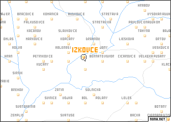
Ižkovce (Slovakia)Ižkovce is a town in Slovakia. An overview map of the region around Ižkovce is displayed below.
regional and 3d topo map of Ižkovce, Slovakia ::
Ižkovce airports ::
The nearest airport is KSC - Kosice, located 53.8 km west of Ižkovce.
Other airports nearby include SUJ - Satu Mare (117.1 km south east), DEB - Debrecen (120.6 km south), TAT - Poprad Tatry (138.4 km north west), BAY - Baia Mare Tautii Magheraus (150.5 km south east), Nearby towns ::
Beša (1.9km south) //
Veľké Raškovce (2.5km west) //
Bernátov Dvor (2.5km east) //
Malé Raškovce (3.1km north west) //
Vojany (3.1km north east) //
Drahňov (3.9km north) //
Kopčany (4.4km north west) //
Slavkovce (6.1km north west) //
Oborín (4.9km west) //
Solnička (7.5km south) //
Stretavka (7.8km north) //
Zatín (8.3km south west) //
[all distances 'as the bird flies' and approximate]  Places with similar names to Ižkovce, Slovakia ::
Disclaimer :: Information on this page comes without warranty of any kind |
||
|
Where is Ižkovce? Elevation and coordinates ::
Latitude (lat): 48°33'0"N Longitude (lon): 21°57'0"E
Elevation (approx.): 104m (map arrows pan, magnifying glasses zoom) |
||
|
Visiting Ižkovce? Hotel/Accommodation ::
Book a hotel in Ižkovce Travel Guide ::
Buy a travel guide for Slovakia rental cars ::
car rental offers GPS waypoint ::
download a GPX waypoint (PoI) of Ižkovce for your GPS receiver
|
||