|
search place name
|
||
Kněždub (Czech Republic)Kněždub is a town in Czech Republic. An overview map of the region around Kněždub is displayed below.
regional and 3d topo map of Kněždub, Czech Republic ::

Kněždub airports ::
The nearest airport is PZY - Piestany, located 43.5 km south east of Kněždub.
Other airports nearby include BRQ - Turany (58.5 km north west), PRV - Prerov (60.4 km north), BTS - Bratislava M R Stefanik (80.3 km south), OSR - Ostrava Mosnov (104.8 km north east), Nearby towns ::
Tvarožná Lhota (1.2km west) //
Hroznová Lhota (3.7km north) //
Radějov (3.1km south west) //
Žeraviny (3.9km north) //
Kozojídky (3.9km north) //
Zarazice (5.7km north) //
Tasov (4.1km north east) //
Vnorovy (6.1km north west) //
Lidéřovice (5.2km north west) //
Strážnice (5.2km west) //
Lipov (5.2km east) //
Veselí nad Moravou (7.5km north) //
Mlýnky (6.1km south west) //
Klvače (7.8km south) //
U Zelenáku (7.4km south east) //
Blatnice (8.9km north east) //
[all distances 'as the bird flies' and approximate] 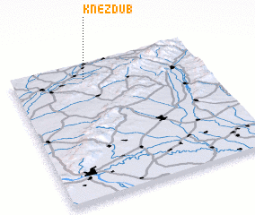 Places with similar names to Kněždub, Czech Republic ::
// Nestby (NO)
Disclaimer :: Information on this page comes without warranty of any kind |
||
|
Where is Kněždub? Elevation and coordinates ::
Latitude (lat): 48°53'0"N Longitude (lon): 17°23'0"E
Elevation (approx.): 176m (map arrows pan, magnifying glasses zoom) |
||
|
Visiting Kněždub? Hotel/Accommodation ::
Book a hotel in Kněždub Travel Guide ::
rental cars ::
car rental offers GPS waypoint ::
download a GPX waypoint (PoI) of Kněždub for your GPS receiver
|
||