|
search place name
|
||
Ostrý Kámen (Czech Republic)Ostrý Kámen is a town in Czech Republic. An overview map of the region around Ostrý Kámen is displayed below.
regional and 3d topo map of Ostrý Kámen, Czech Republic ::

Ostrý Kámen airports ::
The nearest airport is PED - Pardubice, located 55.8 km north west of Ostrý Kámen.
Other airports nearby include BRQ - Turany (69.9 km south), PRV - Prerov (81.1 km south east), OSR - Ostrava Mosnov (123.5 km east), WRO - Wroclaw Strachowice (154.4 km north), Nearby towns ::
Karle (2.2km north west) //
Borová Krčma (2.2km south west) //
Vendolí (3.0km south east) //
Javorník (4.4km north east) //
Kukle (4.4km north east) //
Květná (4.0km south west) //
Mikuleč (5.7km north) //
Radiměř (5.2km south east) //
Svitavy (4.8km east) //
Brlenka (7.5km north) //
Stašov (7.5km south) //
Gajer (7.5km north) //
Chmelík (5.1km west) //
Trstěnice (6.6km north west) //
Čistá (8.2km north west) //
Nový Valdek (7.3km north east) //
Starý Valdek (7.3km north east) //
[all distances 'as the bird flies' and approximate] 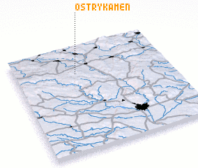 Places with similar names to Ostrý Kámen, Czech Republic ::
Disclaimer :: Information on this page comes without warranty of any kind |
||
|
Where is Ostrý Kámen? Elevation and coordinates ::
Latitude (lat): 49°45'0"N Longitude (lon): 16°24'0"E
Elevation (approx.): 529m (map arrows pan, magnifying glasses zoom) |
||
|
Visiting Ostrý Kámen? Hotel/Accommodation ::
Book a hotel in Ostrý Kámen Travel Guide ::
rental cars ::
car rental offers GPS waypoint ::
download a GPX waypoint (PoI) of Ostrý Kámen for your GPS receiver
|
||