|
search place name
|
||
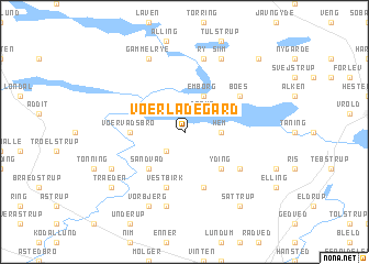
Voerladegård (Vejle, Denmark)Voerladegård is a town in the Vejle region of Denmark. An overview map of the region around Voerladegård is displayed below.
regional and 3d topo map of Voerladegård, Denmark ::
Voerladegård airports ::
The nearest airport is BLL - Billund, located 48.5 km south west of Voerladegård.
Other airports nearby include KRP - Karup (49.9 km north west), AAR - Aarhus (62.5 km north east), ODE - Odense (70.3 km south east), STA - Stauning (87.1 km west), Nearby towns ::
Dørup (2.1km north east) //
Gantrup (2.1km south west) //
Hem (2.1km east) //
Emborg (3.8km north) //
Yding (4.2km south east) //
Sandvad (4.2km south west) //
Vilholt (3.1km west) //
Voervadsbro (3.1km west) //
Vestbirk (5.7km south) //
Østbirk (5.7km south) //
Boes (4.8km north east) //
Såby (4.8km south east) //
Ry (7.5km north) //
Torp (7.5km south) //
Gammel Rye (7.7km north) //
Siim (7.7km north) //
Vorbjerg (7.7km south) //
Gammelstrup (5.6km south west) //
Sattrup (8.0km south east) //
Træden (6.9km south west) //
Firgårde (8.5km north east) //
[all distances 'as the bird flies' and approximate]  Places with similar names to Voerladegård, Denmark :: Disclaimer :: Information on this page comes without warranty of any kind |
||
|
Where is Voerladegård? Elevation and coordinates ::
Latitude (lat): 56°1'0"N Longitude (lon): 9°45'0"E
Elevation (approx.): 52m (map arrows pan, magnifying glasses zoom) |
||
|
Visiting Voerladegård? Hotel/Accommodation ::
Book a hotel in Voerladegård Travel Guide ::
Buy a travel guide for Denmark rental cars ::
car rental offers GPS waypoint ::
download a GPX waypoint (PoI) of Voerladegård for your GPS receiver
|
||