|
search place name
|
||
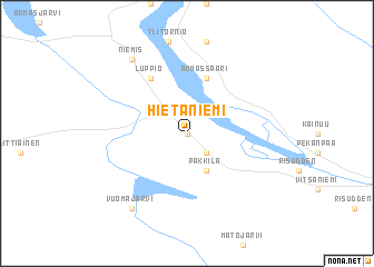
Hietaniemi (Norrbotten, Sweden)Hietaniemi is a town in the Norrbotten region of Sweden. An overview map of the region around Hietaniemi is displayed below.
regional and 3d topo map of Hietaniemi, Sweden ::
Hietaniemi airports ::
The nearest airport is KEM - Kemi Tornio, located 63.9 km south east of Hietaniemi.
Other airports nearby include LLA - Lulea Kallax (103.4 km south west), OUL - Oulu (162.9 km south east), KTT - Kittila (173.2 km north), Nearby towns ::
Koivukylä (0.0km north) //
Hedenäset (2.0km north) //
Bäckesta (2.0km south) //
Päkkilä (3.8km south) //
Armassaari (5.6km north) //
Luppio (5.8km north) //
Niemis (7.7km north) //
Vuomajärvi (7.7km south) //
[all distances 'as the bird flies' and approximate]  Places with similar names to Hietaniemi, Sweden ::
// Huatañuma (PE)
// Hettoniemi (FI)
// Hát Nam (VN)
// Hautaniemi (FI)
// Heteniemi (FI)
// Hietaniemi (FI)
// Hietaniemi (FI)
// Hiidenniemi (FI)
// Huhdanmaa (FI)
// Huhtiniemi (FI)
Disclaimer :: Information on this page comes without warranty of any kind |
||
|
Where is Hietaniemi? Elevation and coordinates ::
Latitude (lat): 66°13'0"N Longitude (lon): 23°41'0"E
(map arrows pan, magnifying glasses zoom) |
||
|
Visiting Hietaniemi? Hotel/Accommodation ::
Book a hotel in Hietaniemi Travel Guide ::
Buy a travel guide for Sweden rental cars ::
car rental offers GPS waypoint ::
download a GPX waypoint (PoI) of Hietaniemi for your GPS receiver
|
||