|
search place name
|
||
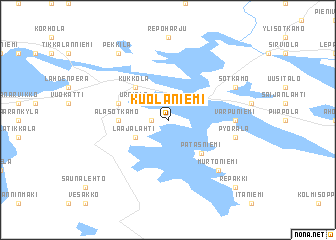
Kuolaniemi (Oulu, Finland)Kuolaniemi is a town in the Oulu region of Finland. An overview map of the region around Kuolaniemi is displayed below.
regional and 3d topo map of Kuolaniemi, Finland ::
Kuolaniemi airports ::
The nearest airport is KAJ - Kajaani, located 38.1 km north west of Kuolaniemi.
Other airports nearby include KUO - Kuopio (124.9 km south), JOE - Joensuu (172.1 km south), KAO - Kuusamo (214.6 km north), VRK - Varkaus (216.4 km south), Nearby towns ::
Liuski (0.8km west) //
Laajalahti (2.5km south west) //
Urpiala (2.5km north west) //
Patasniemi (4.0km south east) //
Kukkola (4.0km north west) //
Alasotkamo (2.4km west) //
Laukkala (3.1km north west) //
Varpuniemi (3.2km east) //
Pyörälä (3.7km south east) //
Murtoniemi (6.1km south east) //
Rytilahti (4.9km north east) //
Sotkamo (4.9km north east) //
Pekkilä (7.8km north) //
Repakki (8.1km south east) //
[all distances 'as the bird flies' and approximate]  Places with similar names to Kuolaniemi, Finland ::
// Kolonomo (PH)
// Klaanemaa (EE)
// Kõlunõmme (EE)
// Glenoma (US)
// Kiloenam (ID)
// Galanema (KE)
// Golnām (IR)
// Kalaniemi (FI)
// Kallioniemi (FI)
// Kelloniemi (FI)
Disclaimer :: Information on this page comes without warranty of any kind |
||
|
Where is Kuolaniemi? Elevation and coordinates ::
Latitude (lat): 64°6'0"N Longitude (lon): 28°21'0"E
(map arrows pan, magnifying glasses zoom) |
||
|
Visiting Kuolaniemi? Hotel/Accommodation ::
Book a hotel in Kuolaniemi Travel Guide ::
Buy a travel guide for Finland rental cars ::
car rental offers GPS waypoint ::
download a GPX waypoint (PoI) of Kuolaniemi for your GPS receiver
|
||