|
search place name
|
||
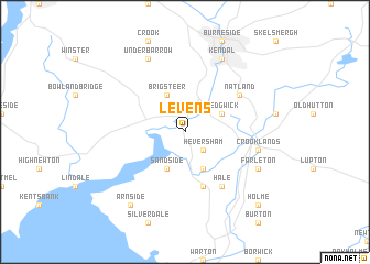
Levens (United Kingdom)Levens is a town in United Kingdom. An overview map of the region around Levens is displayed below.
regional and 3d topo map of Levens, United Kingdom ::
Levens airports ::
The nearest airport is BWF - Barrow Island Walney Island, located 34.0 km south west of Levens.
Other airports nearby include BLK - Blackpool (55.6 km south), CAX - Carlisle (76.5 km north), LBA - Leeds Bradford (85.0 km south east), MME - Teesside Durham Tees Valley Airport (92.6 km east), Nearby towns ::
Heversham (2.1km south east) //
Milnthorpe (3.9km south) //
Sedgwick (2.9km north east) //
Brigsteer (3.9km north) //
Sandside (3.9km south) //
Beetham (5.7km south) //
Hale (6.0km south) //
Natland (4.9km north east) //
Crooklands (4.7km south east) //
Farleton (5.7km south east) //
Kendal (7.7km north) //
Underbarrow (7.7km north) //
Arnside (8.1km south west) //
Holme (8.6km south east) //
[all distances 'as the bird flies' and approximate] 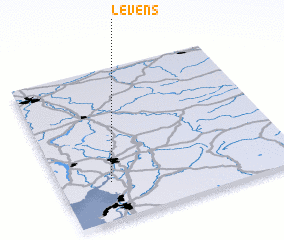 Places with similar names to Levens, United Kingdom ::
// La Venezia (IT)
// Levanzo (IT)
// La Fanosa (ES)
// La Fenosa (ES)
// La Vianeza (CO)
// Louvenza (CG)
// La Vieneza (EC)
// Luvianos (MX)
// Lavannes (FR)
// La Vineuse (FR)
Disclaimer :: Information on this page comes without warranty of any kind |
||
|
Where is Levens? Elevation and coordinates ::
Latitude (lat): 54°15'0"N Longitude (lon): 2°47'0"W
Elevation (approx.): 6m (map arrows pan, magnifying glasses zoom) |
||
|
Visiting Levens? Hotel/Accommodation ::
Book a hotel in Levens Travel Guide ::
rental cars ::
car rental offers GPS waypoint ::
download a GPX waypoint (PoI) of Levens for your GPS receiver
|
||