|
search place name
|
||
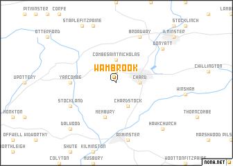
Wambrook (United Kingdom)Wambrook is a town in United Kingdom. An overview map of the region around Wambrook is displayed below.
regional and 3d topo map of Wambrook, United Kingdom ::
Wambrook airports ::
The nearest airport is YEO - Yeovilton, located 29.9 km north east of Wambrook.
Other airports nearby include EXT - Exeter (32.7 km south west), BRS - Bristol (60.7 km north), CWL - Cardiff (63.7 km north), FZO - Bristol Filton (78.1 km north), Nearby towns ::
Higher Wambrook (1.9km north) //
Combe Saint Nicholas (3.7km north) //
Chard (2.3km east) //
Chardstock (3.9km south) //
Membury (5.7km south) //
Yarcombe (4.7km west) //
Broadway (7.8km north) //
Stockland (6.0km south west) //
Donyatt (7.3km north east) //
Hawkchurch (8.8km south east) //
Dalwood (8.8km south west) //
[all distances 'as the bird flies' and approximate]  Places with similar names to Wambrook, United Kingdom ::
Disclaimer :: Information on this page comes without warranty of any kind |
||
|
Where is Wambrook? Elevation and coordinates ::
Latitude (lat): 50°52'0"N Longitude (lon): 3°0'0"W
Elevation (approx.): 188m (map arrows pan, magnifying glasses zoom) |
||
|
Visiting Wambrook? Hotel/Accommodation ::
Book a hotel in Wambrook Travel Guide ::
rental cars ::
car rental offers GPS waypoint ::
download a GPX waypoint (PoI) of Wambrook for your GPS receiver
|
||