|
search place name
|
||
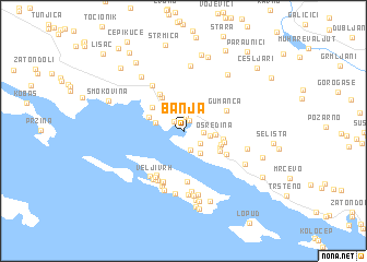
Banja (Croatia)Banja is a town in Croatia. An overview map of the region around Banja is displayed below.
regional and 3d topo map of Banja, Croatia ::
Banja airports ::
The nearest airport is DBV - Dubrovnik, located 39.4 km south east of Banja.
Other airports nearby include OMO - Mostar (56.4 km north), TIV - Tivat (80.1 km south east), TGD - Podgorica (121.3 km east), SJJ - Sarajevo (121.9 km north), Nearby towns ::
Slano (1.2km north) //
Grgurići (1.2km north west) //
Barbijerići (1.4km north) //
Podosojnik (1.5km east) //
Kunja Ljut (2.0km south) //
Grbljava (1.7km south east) //
Gornji Majkovi (2.0km east) //
Prljevići (2.6km south east) //
Slađenovići (2.3km west) //
Osredina (2.4km east) //
Kručica (3.0km north west) //
Drvenik (3.1km south east) //
Donji Majkovi (3.2km south east) //
Banići (3.4km north west) //
Kljunak (3.1km east) //
Ðurjani (3.8km north west) //
Kovačići (3.3km south east) //
Prdenići (3.2km east) //
Trnova (4.2km north west) //
Gumanca (3.8km north east) //
Rožetići (3.9km south east) //
Čemprijesi (5.1km south) //
Govedari (4.9km south west) //
Velji Vrh (5.1km south west) //
Tor (5.4km south) //
Pobrde (5.4km south) //
Šipanska Luka (5.5km south) //
Mravnica (5.3km north west) //
Kaludrica (5.2km south west) //
[all distances 'as the bird flies' and approximate]  Places with similar names to Banja, Croatia ::
Disclaimer :: Information on this page comes without warranty of any kind |
||
|
Where is Banja? Elevation and coordinates ::
Latitude (lat): 42°46'35"N Longitude (lon): 17°53'12"E
Elevation (approx.): 59m (map arrows pan, magnifying glasses zoom) |
||
|
Visiting Banja? Hotel/Accommodation ::
Book a hotel in Banja Travel Guide ::
Buy a travel guide for Croatia rental cars ::
car rental offers GPS waypoint ::
download a GPX waypoint (PoI) of Banja for your GPS receiver
|
||