|
search place name
|
||
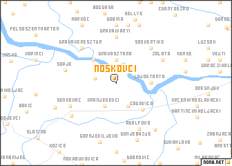
Noskovci (Virovitičko-Podravska Županija, Croatia)Noskovci is a town in the Virovitičko-Podravska Županija region of Croatia. An overview map of the region around Noskovci is displayed below.
regional and 3d topo map of Noskovci, Croatia ::
Noskovci airports ::
The nearest airport is OSI - Osijek, located 85.2 km south east of Noskovci.
Other airports nearby include ZAG - Zagreb (136.0 km west), BUD - Budapest Ferihegy (214.4 km north east), SJJ - Sarajevo (221.4 km south), Nearby towns ::
Gornje Predrijevo (2.5km west) //
Drávasztára (3.8km north) //
Starin (3.8km south) //
Vranješevci (3.8km south) //
Révfalu (4.6km north west) //
Lajostanya (3.9km east) //
Čađavica (5.2km south east) //
Drávaiványi (7.5km north) //
Drávakeresztúr (6.9km north west) //
Sósvertike (6.9km north east) //
Adolfovo (7.8km south) //
Senkovac (6.3km south west) //
Zaláta (6.4km north east) //
Sopje (6.1km west) //
Medinci (7.2km south west) //
Adolfovac (8.7km south east) //
[all distances 'as the bird flies' and approximate]  Places with similar names to Noskovci, Croatia ::
Disclaimer :: Information on this page comes without warranty of any kind |
||
|
Where is Noskovci? Elevation and coordinates ::
Latitude (lat): 45°46'57"N Longitude (lon): 17°49'0"E
Elevation (approx.): 99m (map arrows pan, magnifying glasses zoom) |
||
|
Visiting Noskovci? Hotel/Accommodation ::
Book a hotel in Noskovci Travel Guide ::
Buy a travel guide for Croatia rental cars ::
car rental offers GPS waypoint ::
download a GPX waypoint (PoI) of Noskovci for your GPS receiver
|
||