|
search place name
|
||
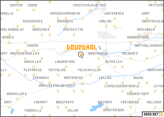
Dourdʼhal (Lorraine, France)Dourdʼhal is a town in the Lorraine region of France. An overview map of the region around Dourdʼhal is displayed below.
regional and 3d topo map of Dourdʼhal, France ::
Dourdʼhal airports ::
The nearest airport is ETZ - Metz Nancy Lorraine, located 33.1 km south west of Dourdʼhal.
Other airports nearby include SCN - Saarbruecken Saarbrucken (34.7 km east), MZM - Metz Frescaty (39.2 km west), ENC - Nancy Essey (55.5 km south west), LUX - Luxemburg Luxembourg (67.3 km north west), Nearby towns ::
Saint-Avold (2.4km east) //
Folschviller (3.9km south) //
Valmont (3.1km south east) //
Laudrefang (3.1km south west) //
Longeville-lès-Saint-Avold (3.1km north west) //
Téting-sur-Nied (5.6km south) //
Porcelette (5.7km north) //
Pontpierre (5.7km south) //
Tritteling (5.2km south west) //
Hémering (7.4km south) //
Altviller (5.2km east) //
Guessling-Hémering (7.5km south) //
Lelling (6.6km south east) //
Varsberg (7.8km north) //
Boucheporn (7.4km north west) //
Carling (8.3km north east) //
Vahl-lés-Faulquemont (8.3km south west) //
Faulquemont (7.4km south west) //
LʼHôpital (8.9km north east) //
Bisten-en-Lorraine (8.9km north west) //
[all distances 'as the bird flies' and approximate]  Places with similar names to Dourdʼhal, France ::
// Tar Dahali (BD)
Disclaimer :: Information on this page comes without warranty of any kind |
||
|
Where is Dourdʼhal? Elevation and coordinates ::
Latitude (lat): 49°6'0"N Longitude (lon): 6°40'0"E
Elevation (approx.): 275m (map arrows pan, magnifying glasses zoom) |
||
|
Visiting Dourdʼhal? Hotel/Accommodation ::
Book a hotel in Dourdʼhal Travel Guide ::
Buy a travel guide for France rental cars ::
car rental offers GPS waypoint ::
download a GPX waypoint (PoI) of Dourdʼhal for your GPS receiver
|
||