|
search place name
|
||
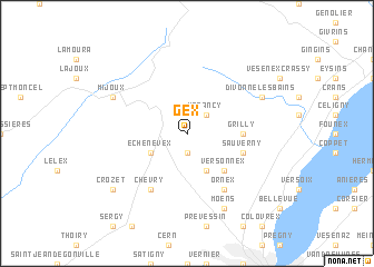
Gex (Rhône-Alpes, France)Gex is a town in the Rhône-Alpes region of France. An overview map of the region around Gex is displayed below.
regional and 3d topo map of Gex, France ::
Gex airports ::
The nearest airport is GVA - Geneva Cointrin, located 11.1 km south of Gex.
Other airports nearby include QNJ - Annemasse (22.1 km south east), NCY - Annecy Meythet (45.0 km south), XBK - Bourg Ceyzeriat (61.5 km west), CMF - Chambery Aix Les Bains (78.6 km south), Nearby towns ::
Cessy (1.9km south) //
Vesancy (2.3km north east) //
Ségny (3.9km south) //
Échenevex (3.2km south west) //
Versonnex (4.5km south east) //
Grilly (3.8km east) //
Sauverny (4.3km south east) //
Ornex (6.1km south east) //
Chevry (6.1km south west) //
Moëns (7.8km south) //
Divonne-les-Bains (6.3km north east) //
Mijoux (6.3km north west) //
Crozet (7.6km south west) //
[all distances 'as the bird flies' and approximate] 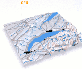 Places with similar names to Gex, France ::
Disclaimer :: Information on this page comes without warranty of any kind |
||
|
Where is Gex? Elevation and coordinates ::
Latitude (lat): 46°20'0"N Longitude (lon): 6°4'0"E
Elevation (approx.): 579m (map arrows pan, magnifying glasses zoom) |
||
|
Visiting Gex? Hotel/Accommodation ::
Book a hotel in Gex Travel Guide ::
Buy a travel guide for France rental cars ::
car rental offers GPS waypoint ::
download a GPX waypoint (PoI) of Gex for your GPS receiver
|
||