|
search place name
|
||
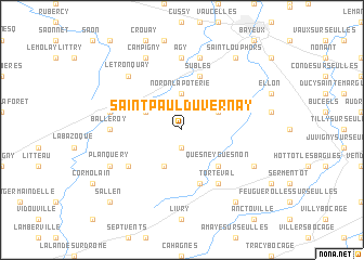
Saint-Paul-du-Vernay (Basse-Normandie, France)Saint-Paul-du-Vernay is a town in the Basse-Normandie region of France. An overview map of the region around Saint-Paul-du-Vernay is displayed below.
regional and 3d topo map of Saint-Paul-du-Vernay, France ::
Saint-Paul-du-Vernay airports ::
The nearest airport is CFR - Caen Carpiquet, located 23.1 km east of Saint-Paul-du-Vernay.
Other airports nearby include DOL - Deauville St Gatien (70.0 km east), CER - Cherbourg Maupertus (72.8 km north west), LEH - Le Havre Octeville (73.3 km north east), JER - Jersey (104.2 km west), Nearby towns ::
Cahagnolles (1.9km south) //
Noron-la-Poterie (3.7km north) //
Sainte-Honorine-de-Ducy (3.9km south) //
Castillon (3.1km north west) //
Trungy (3.1km north east) //
Quesney-Guesnon (4.4km south east) //
Subles (5.7km north) //
Arganchy (5.7km north) //
Parfouru-lʼÉclin (5.7km south) //
Foulognes (5.2km south west) //
Torteval (6.1km south east) //
Balleroy (4.8km west) //
Agy (7.4km north) //
Vaubadon (5.2km west) //
Ranchy (7.5km north) //
Le Tronquay (6.6km north west) //
Planquery (6.1km south west) //
Campigny (7.8km north) //
Longraye (6.1km south east) //
Saint-Germain-dʼEctot (8.3km south east) //
Guéron (8.3km north east) //
Saint-Loup-Hors (8.3km north east) //
Sallen (8.9km south west) //
[all distances 'as the bird flies' and approximate]  Places with similar names to Saint-Paul-du-Vernay, France ::
// Saint-Paul-de-Vern (FR)
Disclaimer :: Information on this page comes without warranty of any kind |
||
|
Where is Saint-Paul-du-Vernay? Elevation and coordinates ::
Latitude (lat): 49°11'0"N Longitude (lon): 0°46'0"W
Elevation (approx.): 119m (map arrows pan, magnifying glasses zoom) |
||
|
Visiting Saint-Paul-du-Vernay? Hotel/Accommodation ::
Book a hotel in Saint-Paul-du-Vernay Travel Guide ::
Buy a travel guide for France rental cars ::
car rental offers GPS waypoint ::
download a GPX waypoint (PoI) of Saint-Paul-du-Vernay for your GPS receiver
|
||