|
search place name
|
||
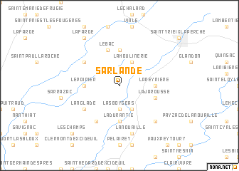
Sarlande (Aquitaine, France)Sarlande is a town in the Aquitaine region of France. An overview map of the region around Sarlande is displayed below.
regional and 3d topo map of Sarlande, France ::
Sarlande airports ::
The nearest airport is PGX - Perigueux Bassillac, located 36.6 km south west of Sarlande.
Other airports nearby include BVE - Brive La Roche (43.2 km south east), LIG - Limoges Bellegarde (46.1 km north), ANG - Angouleme Brie Champniers (76.4 km north west), EGC - Bergerac Roumaniere (83.9 km south west), Nearby towns ::
Mériol (2.3km north west) //
Las Boygeas (3.7km south) //
La Moulinerie (3.9km north) //
Angoisse (3.9km south) //
La Jarousse (5.6km north) //
Le Poirier (3.9km west) //
La Peyrière (3.9km east) //
La Durantie (5.6km south) //
Le Bac (5.7km north) //
La Jarousse (4.3km south east) //
Jumilhac-le-Grand (5.4km north west) //
Langlade (5.4km south west) //
Dussac (6.1km south west) //
Lanouaille (7.5km south) //
Chaud (6.8km south east) //
La Farge (8.4km north west) //
Les Champs (9.1km south west) //
[all distances 'as the bird flies' and approximate]  Places with similar names to Sarlande, France ::
// Saraland (US)
// Sørland (NO)
// Sørland (NO)
// Scîrlenţea (RO)
// Saré Landia (SN)
// Sūrlandai (PK)
// Sara Linda (VE)
// Serrolândia (BR)
// Sierra Linda (US)
// Saarlanti (FI)
Disclaimer :: Information on this page comes without warranty of any kind |
||
|
Where is Sarlande? Elevation and coordinates ::
Latitude (lat): 45°27'0"N Longitude (lon): 1°7'0"E
Elevation (approx.): 323m (map arrows pan, magnifying glasses zoom) |
||
|
Visiting Sarlande? Hotel/Accommodation ::
Book a hotel in Sarlande Travel Guide ::
Buy a travel guide for France rental cars ::
car rental offers GPS waypoint ::
download a GPX waypoint (PoI) of Sarlande for your GPS receiver
|
||